“You don't need to climb a mountain to know that it's high.”
― Paulo Coelho, Aleph
Nestled within a river valley in the Southern Sierra Madre is a
paradise known as Barangay Daraitan, which lies within the boundaries of Tanay,
Rizal. What was previously a haven for illegal loggers, has now become a
sanctuary for mountaineers, hikers, weekend warriors, and casual tourists that
ceaselessly flock to the place especially during holidays and weekends. So, as
our first hike for 2016, we finally decided to hike in Daraitan.
 |
| Mt. Mamara...taken somewhere along the Tinipak River |
 |
| Mt. Mamara...as seen a few meters from the jump off point |
 |
| Fly high...Skookum jump |
As our plan to hire a van did not materialize, we decided to just
meet at the designated stop for jeepneys bound for Tanay opposite the
Shangri-la Plaza Mall along Shaw Boulevard in Mandaluyong City. It was already
0445H when we boarded a jeepney, hoping that we are still within the 300 hikers
to summit in a day quota that was recently imposed in Barangay Daraitan. We
ultimately arrived at the Tanay Public Market at 0610H together with at least
12 hikers that flagged the jeepney somewhere in Cainta and Pasig.
It took us more than an hour and twenty minutes to negotiate the
bumpy tricycle ride from the Public Market to Daraitan. We even had to alight
from the tricycle for it to be able to negotiate an uphill portion of the
General Marking Road (Yes, this normally happens in this dirt road).
 |
| From the Public Market to Sampaloc |
While the tricycle driver has assured us that there were still
not that many hikers who passed by the highway, our hopes were somewhat
dampened by the huge crowd at the registration area. It was short of mayhem,
with a fiesta like atmosphere. Truly, we failed to beat the 300-hiker rule. Luckily,
they offered us an alternative itinerary that includes hiking up Mt. Mamara, Tinipak River, and Maytuntong Cave.
 |
| We needed to alight from the tricycle because of the steep and muddy dirt road |
 |
| Mt. Daraitan....Mt. Mamara is on the right side |
Mt. Mamara has recently been opened as a new tramping ground in
Daraitan, mainly to serve as an alternative hike especially to those who fail
to beat the 300-hiker rule. Mt. Mamara is the mountain on the other side of the
river opposite Mt. Daraitan. It can be considered as a the younger brother of Mt. Daraitan since only a river actually separates the two mountains.
We then paid the mandatory registration fee of Php20.00 and
secured the services of a local guide. After having breakfast and buying food
for lunch at the nearby eatery, we started to follow the road that leads to the
south east (right from the registration area). It was already 0810H when we
commenced hiking.
The concrete pavement turned into a dirt path and soon after
passing by the residential area. We even passed by a cemetery and then followed the river until we reached the
area were we did some bouldering. Nevertheless, we were left breathless not
because of the hike but by reason of the quaint, serene, and scenic landscape.
It was indeed breathtaking.
 |
| And there goes the river |
 |
| The local cemetery |
 |
| I'll have a dip next time |
 |
| Sweeper mode |
 |
| Boulders...want some? |
 |
| Thank God for all these! |
 |
| ...the water is really immaculate |
 |
| Breathtaking |
 |
| Hi ho...hi ho! |
 |
| We are ready! |
 |
| Goats |
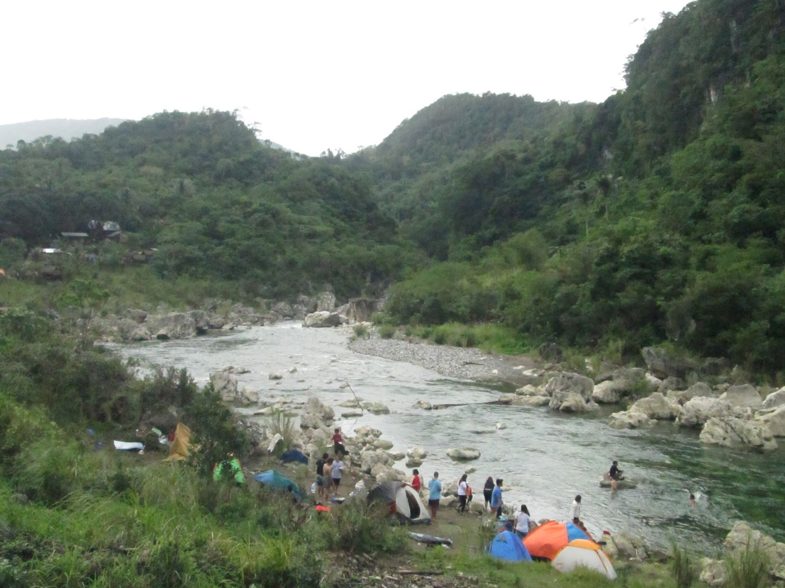
An hour into the hike, we finally reached the camp site. Here, we also had to pay P20.00 for another registration fee (because we have supposedly crossed the boundary and formally entered General Nakar, Quezon). After spending some time for a breather, we continued towards the trail leading to the Maytuntong Cave which is actually located at the base of Mt. Mamara. We then had to carefully negotiate the slippery trail especially the makeshift wooden stairs leading down to the river where another of bouldering ensued.
 |
| Some would camp along the riverbank |
 |
| So now...we are supposedly no longer in Rizal but in Quezon. |
 |
| Approaching the campsite |
 |
| Registration 2 |
 |
| From the campsite....we proceed to the Tinipak River |
 |
| Careful |
 |
| We go up...then down to the other side. |
Good thing for hikers, there is now a makeshift wooden bridge on top of the boulders where people had to carefully do bouldering in crossing the river from one bank to the other side. However, one has to pay Php5.00 for crossing the bridge to and fro.
 |
| Amazing |
 |
| The famous Tinipak Wall |
 |
| Lyca, Cathy, Jenica, Me, Gani |
 |
| Water coming out from the cave... |
 |
| Makeshift Bridge |
 |
| I hope all rivers would be this clean |
 |
| We are crossing the bridge. |
 |
| Boulders |
 |
| Tinipak River |
 |
| That's the other side of the river |
On the other side, we immediately had to negotiate the incessant
and lung-busting assault to the summit of Mt. Mamara. The trail is somewhat akin
to that of the new trail in Pico de Loro, Mt. Balungao, and even the initial
approaches of Mt. Tagapo. There are instances where one needs to cling to
rocks, branches, wooden planks and handles specifically made by the locals to
support hikers. As the trail is forested, the tree canopy protected us from the
rays of the sun throughout the climb.
 |
| Up we go... |
 |
| Mushroom |
 |
| So the locals made it easier for hikers to climb |
 |
| with Lyka...along the trail |
 |
| Just part of the trail. |
At 1030H, we reached the view deck and eagerly waited for our
turn to take photos and selfies in the area. This view deck is an out crop of
limestones similar to the view decks in the other mountains in the Sierra Madre
like Mt. Binakayan and Mt. Hapunang Banoi.
 |
| at the viewdeck |
 |
| with the rest of Sierra Madre as background |
 |
| Dayhikers...looking for some adventure |
 |
| Aprub! |
 |
| Hiking Buddies |
 |
| Mt. Daraitan...maybe next time |
 |
| Rockies |
The actual Summit Area of Mt. Mamara is just a few meters from
the viewdeck. Since the Summit is actually forested and maybe due to the fact
that Mt. Mamara is still newly introduced to the mountaineering world, the
other highlight at the top is the camp site which offers a panoramic view of
the Daraitan river valley. This campsite is about 5 minutes from the viewdeck
and may accommodate up to 10 tents. However, there are no water sources close
to it so hikers who would spend the night there should bring sufficient water
beforehand.
 |
| Camp site at the Summit of Mt. Mamara |
 |
| Daraitan River Valley |
 |
| Engr. |
 |
| Daraitan |
 |
| Heeheehee |
It was already 1145H when we left the Summit for Maytuntong Cave.
The trail was really slippery because of the sporadic rain while we were
ascending the mountain. Also, as the trail is still new, the sheer number of
hikers that go up and down Mt. Mamara resulted to bottlenecks that further
hampered our progress. I could only imagine the foot traffic in Mt. Daraitan at
that time since it is expected that less hikers opted to climb Mt. Mamara as
compared to Mt. Daraitan.
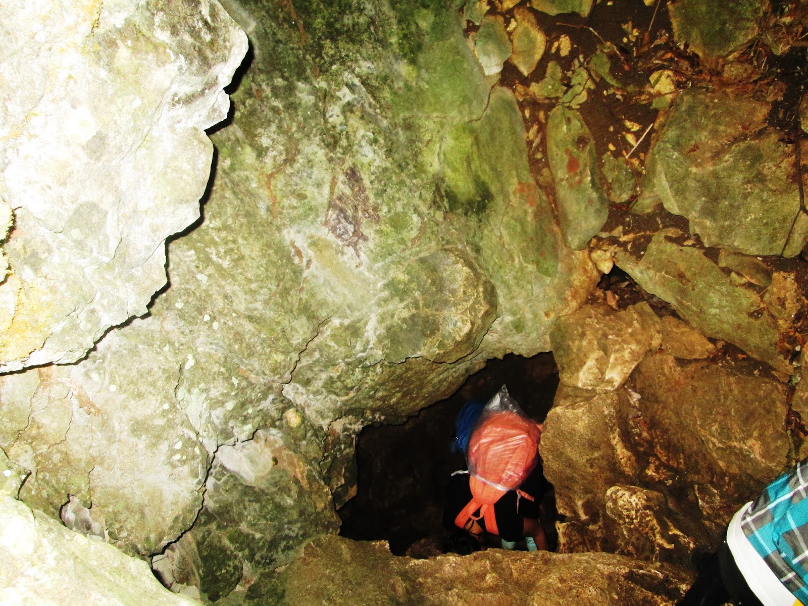
We ultimately reached the entrance to Maytuntong Cave at 1315H
and we had to queue in order to wait for our turn to enter the cave and have a
dip in its underground river. At 1410H, we started to enter the underground
paradise that is Maytuntong Cave.
 |
| Queuing at the Maytuntong Cave |
One needs to harness his/her acrobatic skills and body
coordination in descending the cave. Just after the ladder, where we had to
twist and turn, we had to negotiate slippery (because people who come and go
are wet) boulders and rock slabs. Nonetheless, everybody were in awe of the
rock formations, especially the stalactites that hang from the above.
 |
| While waiting for our turn. |
 |
| The cave entrance |
 |
| Ooopppss...we're going down! |
 |
| Let's go! |
 |
| Hey...wait for me! |
 |
| It's a different world. |
 |
| Magnificent cave |
As we neared the natural pool, we could hear the rushing sound of
the free-flowing underground river. The pool can easily accommodate 20 people. And
the water, is really ice cold. Nonetheless, once your body adjusts, you can get
used to it. We really enjoyed our stay inside the cave since we lost track of
time and were in fact surprised that it was already 1500H when we emerged from
the abyss.
 |
| A wonderful experience |
 |
| Water is life |
 |
| Easy does it |
 |
| The rushing waters going underground. |
 |
| The Natural Pool |
 |
| Daraitan is not complete without taking a dip in this pool. |
 |
| Bbrrrr.... |
 |
| Having fun underground |
 |
| Crystal clear waters |
We then immediately went to explore the scenic spots along the
Tinipak River. There are a lot of people there. Hence, it really was an effort
to get the best views without any photobombers around. Of course, the foot
traffic was a concern for us since we have to make sure that we are able to get
a ride home. As we had countless photo ops along the trail back to the jump off
point, we decided to avail of the services of a tricycle from the area they
call Jampolan (the area where the first set of boulders are located) up to the
house near the Barangay Hall where we freshened up.
 |
| Tired...but we really enjoyed the hike. |
 |
| Skookum |
 |
| The tribal council...heehee |
 |
| Homeward Bound |
 |
| who would not be mesmerized by this |
After feasting on the different offerings of the locals, we
decided to just hire a tricycle back to Tanay Proper instead of riding the
jeepney, which decision proved to be a stroke of genius since we arrived
earlier than the jeepney that obviously still needed to wait for other
passengers.
Mt. Mamara, is actually a worthy climb considering the challenges that abound along its trail. Also, I can sense that there will be a lot of hikers and mountaineers who will do a twinhike of Daraitan and Mamara in the future.
Brgy. Daraitan has really become one of the more popular
adventure spots near Manila. I’ve never seen a river as clean as Tinipak River
and was really amazed of the Maytuntong Cave. I just hope that the climbers,
including the army of weekend warriors who troop there will be more responsible
in protecting the place. So that the beauty of Daraitan shall remain to be a
blessing even to future generations instead of being a curse to its own cause.
Traipsing Chronicles 032
001.031.016
Mt. Mamara
Brgy. Daraitan, Tanay, Rizal
Jump off point:
Minor Climb: 3/10
Highlights: River Trekking, Bouldering, chance to go caving and swimming in the river; panoramic views of the Daraitan River Valley and the rest of Sierra Madre
Actual Itinerary
0400H - Meet-up Chowking Shaw Boulevard
0445H - Board jeepney bound for Tanay, Rizal
0610H - Arrival in Tanay Public Market
0620H - Hire Tricycle going to Daraitan
0645H - Change tricycle at the Marifanta Highway
0730H - Arrival at the Brgy. Hall in Daraitan (JOP) –
Register / Secure Guide / Breakfast
0810H - Start Hiking to Mt. Mamara via river trail
0910H - Arrival at the Camp Site / Register
0920H - Arrival at the bank of Tinipak River
0930H - Arrival at the base of Mt. Mamara / Entrance
of Maytuntong Cave / Commence Ascent
1030H - Arrival at the view deck / Photo Ops
1050H - Proceed to Summit / Camp Site
1100H
- Arrival at the Camp Site - more
photo-ops / L U N C H
1145H - Started to descend the mountain
1315H - Arrival at the entrance to Maytuntong Cave /
Queued up for our turn
1410H - Started exploring Maytuntong Cave
1500H - Emerged from the cave / Photo Ops along the
banks of the Tinipak
1530H - Back at the Camp Site
1600H - Back at Jampolan / Ride tricycle back to the
JOP
1610H - Back at JOP / Wash up
1640H - Hire tricycle / Back to Tanay Public Market
1800H - Arrival at the Public Market / Wait for the
UV Express
1930H - Left Tanay Public Market for Starmall
EDSA-Shaw
2100H - Arrival at Starmall EDSA-
Getting There
Private Transportation.
Via Cogeo - From EDSA - CUBAO area (LRT 2 Station), traverse Aurora Boulevard and continue straight, then just follow the Marifanta Highway. You will be passing by SM Marikina, Sta. Lucia Grand Mall, SM Masinag, and Cogeo. You will then traverse the uphill and zigzag roads in Boso-Boso.
You will pass by Palo Alto and Garden Cottages. Go past the Batangasan junction that leads to the jump off for Mt. Batolusong. You will then pass by the Sierra Madre Resort as well as the Sampaloc Junction. You will then pass by the road leading to the Regina Rica.
Continue straight but watch out for the markers on the left side of the road. At the welcome sign / markers, turn left to General Marking Road. Continue straight until you reach Daraitan. But again, you still have to cross the wooden bridge. Brgy. Daraitan is still 11 kilometers of bumpy ride from the Marifanta Highway.
Via Taytay - Antipolo - From EDSA-Ortigas, follow Ortigas Avenue until you reach Antipolo. In doing so, you will pass by Pasig, Cainta, and Taytay. Once in Antipolo, turn right towards the Rizal Provincial Capitol and just follow the highway and you will pass by Shopwise.
A few minutes from there, you then pass by the zigzag road until you reach the town of Teresa. Just before the Baras Town Proper, you may choose to follow the highway on the left (right leads to Baras Town Proper). Once in Tanay, you will reach a junction where a Shell gasoline station is located. Turn left and follow the up and winding road. Once you reach the junction, turn left and continue straight until you see the welcome arch and markers on the left side of the road as specified above.
***Should you decide to bring your own vehicle, make sure that your vehicle is in good running condition since the Gen. Marking Road has steep and continuous ascents. Also, the road becomes muddy and slippery during the rainy season. Sedans may be able to survive the trip to Daraitan. However, it will really take a toll with (especially the shocks and suspension) your vehicle.
Public Transportation
From Cubao, take a jeep or UV Express to Cogeo Gate 2 in Antipolo (Php35). Once in Cogeo, proceed to the jeepney terminal adjacent to the market and take the jeepney going to Sampaloc/Tanay. Once in Sampaloc, hail a tricycle going to Barangay Daraitan.
Guides. Local guides are mandatory. Php500.00 for dayhikes and
Php1250.00 for an overnight. The Guide Fee is good for up to 10
hikers/climbers.
Also, it is helpful to take note of the 300 hikers a day rule.
Fees.
Registration Fee – Php20.00
Pagsangahan Boundary / Camp Site – Php20.00
Wooden Bridge – Php5.00
Campsites. Hikers may camp along designated areas of the Tinipak
River, the Camp Site (where there is a store cum carinderia), the summit of Mt.
Daraitan, and the summit of Mt. Mamara. However, there are no water sources at
the summit of Daraitan and Mamara. Hence, hikers who camp at the summit should
already bring enough water on the way up.
Twinhike. A twinhike of Mt. Daraitan and Mt. Mamara is possible.
However, adjustments to one’s itinerary should be made considering the factors
that affect the travel time to and from Brgy. Daraitan. Also, there are other
mountains and peaks in the area that are being considered for hiking / tourism
purposes.
 |
| Between Mt. Mamara and Mt. Daraitan |
Food. There are a lot of stores and even eateries in Daraitan
proper (near the Registration Area/Barangay Hall). You may eat breakfast or buy
packed lunch in any of the eateries. Staple include the silog meals,
lomi, etc.
Boundary Dispute. There is a boundary dispute between Brgy.
Daraitan, Tanay, Rizal and Sitio Cablao, Brgy. Pagsangahan, General Nakar,
Quezon concerning the area. However, our guide told us that the same was
already resolved in favor of Daraitan.
Treasure Hunting / Japanese War Loot. Stories about the lost
treasure of the Japanese Imperial Army during the World War II abound in the
Daraitan Area. There were claims that treasures have already been recovered in
different sites around the place. This is by reason of the fact that the retreating
Japanese forces supposedly crossed through Daraitan in their attempt to reach Infanta,
Quezon.
 |
| Bye |
 |
| Great Photo guys |
 |
| Swim? |
 |
| We'll cross the bridge when we get there....haahaa |
 |
| Crossing the bridge |


Tinipak River is beautiful! Would love to visit this area.
ReplyDeleteYes it really is a must-visit. The most beautiful and the clearest river I've seen.
Deleteare there any guides that can be contacted, if so can anyone give their contact numbers and info?
ReplyDeleteGuides are always available at the registration area in Daraitan. The guides/porters are assigned on rotation basis. In other words, even if you contact someone, there is no assurance that such person will eventually be assigned as your guide for the day.
DeleteYou can just go straight to the Multi-Purpose Building / Registration Area. Even on weekdays, they can easily assign guides to your group. But if you really want to contact someone in Daraitan, you may call +639069533470 – Willy (Guide) or you may send a message to the Daraitan Tour Guide Association. They have page in FB.