“Thousands of tired, nerve-shaken, over-civilized people are beginning to find out that going to the mountains is going home; that wildness is a necessity”
― John Muir, Our National Parks
Mt. 387 (also known as Batong Amat) has instantly gained its ground as one of the more popular climbs in Central Luzon since the time it was introduced to the mountaineering community at the onset of 2017. Now, it has become as one of the favorites even by newbies and occasional hikers because mainly of two factors: 1. the supposed view of the so-called Chocolate Hills of the North; and 2. the cool dip at the nearby Aloha Falls after the climb.
 |
| What is referred to as the Chocolate Hills of the North is actually a part of the Caraballo Mountain Range....notice a faint Mt. Arayat in the background. |
 |
| The Stone Marker near the Summit...the actual Summit is the clearing about 200 meters from this area. |
 |
| Solitude |
 |
| Aloha Falls |
In less than three hours, we were already at the junction in San Jose City buying our packed lunch at the nearby fastfood joint and even had the time to try the local crispy goto al fresco at the roadside makeshift eatery. It was already 3:10am when we left the area and continued towards Brgy. Puncan in nearby Carranglan town.
 |
| Delivery Man |

We eventually arrived in Brgy. Puncan after 15 to 20 minutes where we were fetched by local guides along the Maharlika Highway, and were led to the jumpoff point some 150 meters from there.(Just a tip...the way to the JOP is a dirt path before a waiting shed on the left side of the highway. This shed is located about 60 meters opposite the INC Chapel in Brgy. Puncan.).
After a short chitchat with the guides, we subsequently were invited for a briefing about the relevant FAQs. During the short briefing, we were first taken back to history. It was explained to us in detail that the trail up Mt. 387 became part of the historical trails used by the Japanese forces led by General Yamashita in World War II. In fact, there are a number of foxholes along the trail and it is likewise common to see spent bullets and casings in the area. This is no surprise since the mountain actually guards the entrance to the Cagayan Valley, which ultimately leads to the famed Dalton Pass. In view of the foregoing, the area is also a well-known haven for treasure hunting activities.
The mountain was christened Mt. 387 because it is part of an area comprising 387.9 hectares within the 65,000++ hectares of the Talavera Watershed Forest Reserve. True to its status as a watershed area, the locals entered into an agreement with the Department of Environment and Natural Resources (DENR) for the reforestation and upkeep of the surrounding mountains. Accordingly, the locals have enlisted the help of climbers / hikers in their reforestation activities. During the rainy season, each hiker is made to plant at least 2 seedlings (one may buy additional seedlings if preferred) at the designated reforestation areas along the trail. Seedlings are available for sale at the jumpoff point. During the dry season, hikers are required to help in tree nurturing by bringing at least a liter of water to nourish the planted seedlings. Simple, but is actually ingenious. This program is also referred as "Kalinga sa Kalikasan ng Puncan".
 |
| The Seedlings that I carried and planted. |
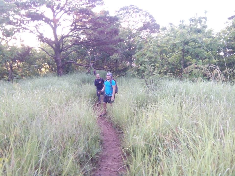
After paying the mandatory registration fees, we went to fix our gears and hyped each other for the ensuing climb. It was already 0430H when we informed the guides of our readiness to start the climb. We then continued towards the dirt path at the back of the kubo, and had our short prayer before the climb proper. Thereafter, continued towards South until the we finally reached the trail leading up the mountain.
The trail ascended into the forest teeming with dipterocarp trees. As we got higher in elevation and passed by woodlands, the trail became gradual to moderate incline. Surprisingly, we seem to have followed the highway southwards as it became pretty obvious that we were now adjacent to especially when we finally reach the ridge and ascended the same. We passed by a bamboo grove similar to that in Mt. Tagapo and Pico de Loro. A few minutes from here is the 1st viewpoint. It is somewhat a flat surface where a plant with big leaves (sorry don't know the name) abound. Here, we decided to take a longer rest and enjoy the view of the sun rising over the Sierra Madre. We likewise reached a foxhole strategically placed along the trail, which actually affords a commanding view of the highway and the plain below.
 |
| Morning has broken! |
 |
| Caraballo....far right is the Sierra Madre |
 |
| 1st view point |
 |
| The grassland after the 1st viewpoint...before the tree-planting area. |
 |
| One of the foxholes in the area |
A few meters from here is where we encountered the first pine trees in the area. Although it really is surprising to see Benguet Pine in this part of the Caraballo Mountain Range, our guide informed us that the pine trees in the areas were actually planted during the tree planting activities of the DENR in the past. A few meters from here are the visible vestiges of the on-going tree planting / reforestation activity in Mt. 387.
As we pushed forward, we eventually reached the pine tree where hikers usually take pictures. The clearing / grassland after the aforementioned pine tree is where we ultimately decided to plant the seedlings that we have brought from the JOP. I noticed that the seedlings were actually of the Narra variety. Hopefully, these seedlings mature and live for years to benefit our and the next generation.
 |
| Surprisingly, pine trees abound in the area |
 |
| Click! |
 |
| At the clearing after that famous pine tree (at the back) that hikers usually climb for photo-ops. |
 |
| With a view of the valley between the Caraballo and the Sierra Madre (that is Carranglan). |
 |
| Silhoutte |
After planting, we continued the hike as the trail snaked through the grassland, now with a more prominent cogon overgrowth due to the rainy season. The open trail with its rolling terrain continued until we finally reached another viewpoint. There are also newly-planted trees here. One notable feature of the trees planted are the plastic containers next to the plants that are meant to collect rainwater.

 |
| Balik-Bundok |
 |
| Approaching Batong Amat |

The dirt path again led us to a clearing with a more inclined feature, to which the Batong Amat Peace Park followed. The view is simply breathtaking. Though green because of the grass in this time of the year, the supposed Chocolate Hills of the North still is impressive. During the dry season, it usually is chocolate brown with a certain pinch of yellow. Likewise, the views of the Caraballo and Sierra Madre Mountain ranges, as well as the fertile plains of Central Luzon, were simply sensational.
 |
| At the Bating Amat |


The campsite can easily accommodate big groups and I can just imagine how splendid the view would be at night, with all the lights below and the sky and stars above. Our guide said that there is a water source nearby, but when we pressed him again about its location (since we may plan the overnight hike accordingly), he gave us no answer.


The trunk of the Lovers' Tree has now been enclosed with wooden posts in order to preserve it from unscrupulous campers who (according to our guide) tend to remove the bark of the tree. (Whatever happened to LNT peeps?).
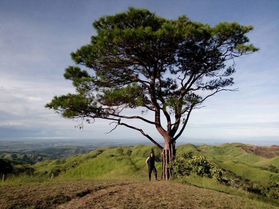 |
| The Campsite...and the Lovers' Pine Tree |
 |
| The makeshift shelter of the guides when they spend overnight in the mountain...with the Zambales Mountain Range, Mt. Amorong and Mt. Balungao in the background |
After spending a good amount of time for photo-ops and additional chit-chat, we then decided to continue with the traverse to Aloha Falls.
We had to backtrail towards the North and then continued towards a grassland until we reached a dead tree that remains to tower above the others. The trail is actually covered by cogon overgrowth at times until we arrived at a bamboo grove (buhoan). One thing about hiking in a bamboo grove is that the trail tends to become more slippery than ever during the rainy season. Hence, we just had to be careful and cling on to whatever trunk or branch that is readily available along the trail.
 |
| The trail going to Aloha Falls (from the campsite)...a trail on the right (before the hikers) goes to the summit. |
 |
| Deadwood |
After this, we again encountered another bamboo grove. While it helps to have something to cling on, the bamboo and bush along the trail similarly caused cuts, especially in our arms and hands. The steep and slippery conditions of the trail really made the descent harder than expected.
 |
| Steep...slippery trail when wet |
 |
| careful now... |
 |
| Bamboo Grove...with slippery and steep trail |
The ensuing trek to Aloha Falls required us to do some river trekking. Hence, if you do not want to get your shoes wet, you have to bring your own sandals. The water at the pool is refreshing and is able to ease your weary body.
 |
| Aloha Falls |
 |
| Refreshing |
 |
| Butterflies |
 |
| River Trekking |
 |
| The Elf Truck |
 |
| Uwian Na! |
 |
| Off to the JOP |
Tramping Chronicles #045
007.009.017
Mt. 387 / Batong Amat Traverse
Jump off point: Brgy. Puncan, Carranglan, Nueva Ecija
Minor Climb: Traverse to Aloha Falls 4/10; Backtrail 2/10
Highlights: Historic Forest Trail; Panoramic views of the Central Plains of Luzon, Caraballo Mountain Range, Sierra Madre Mountain Range, Mt. Arayat, Mt. Balungao, Mt. Amorong, Mt. Lakay; pine trees (including the "lovers' tree"); grassland; and Aloha Falls
ACTUAL ITINERARY
2300H - Meet-up at McDonalds Panay Ave. cor. EDSA
2345H - Departure
0235H - Mcdonald's San Jose City (Junction) / Ate Crispy Goto at the nearby roadside stall.
0310H - Continued Drive to Carranglan
0330H - Arrival at the jumpoff point (Carranglan, Nueva Ecija) / Secure Guide / Briefing
0430H - Commenced Hiking
0510H - Arrival at the 1st view deck (clearing where small trees with big leaves abound)
0535H - Arrival at the pine tree before the area where we planted our seedlings.
0540H - Tree Planting after the 1st pine tree
0545H - Continued Hike
0605H - Arrival at the other view deck (after the clearing / with a robust pine tree)
0620H - Continued hike towards the grassland
0625H - Arrival at view deck / open area before the solitary pine tree next to the trail (photo ops)
0635H - Arrival at Batong Amat Peace Park / Photo-ops
0645H - Arrival at the Summit Area / Photo-ops
0730H - Continued towards the Camp site / Lover's Pine Tree
0735H - Arrival at the Camp site / Lover's Pine Tree
0745H - Commenced traverse to Aloha Falls / Steep and slippery trail
0800H - Arrival at the dead tree (presumably hit by lightning)
0810H - Arrival at the bamboo grove
0825H - Arrival at the clearing before the final descent towards the river (steep descent)
0840H - Arrival at the 2nd bamboo grove before the junction to Aloha Falls
0900H - Arrival at the base of the mountain / junction to Aloha Falls / Long Rest Stop
0935H - Continued hike to Aloha Falls / River Trekking
0945H - Arrival at Aloha Falls / Swimming
1115H - Backtrail towards the river
1125H - Arrival at the truck pick-up point
1135H - Arrival of the truck
1150H - Back at the jumpoff point / Washup
1310H - En Route back to Metro Manila
1325H - Lunch at a local stopover (kambingan)
1410H - Back on the road / With stop over at the City Mall in SCTEX (Concepcion, Tarlac)
1730H - Back in Quezon City
***Thanks to Allan, Tony, and Domeng for the photos used in this post.
How-to-get-there - Mt. 387 / Mt. Batong Amat is
accessible to both private and public transport. And with the constructions of
the TPLEX, it has even become more accessible than ever. While most van
operators hired by climb organizers would take the SCTEX-Aliaga-Maharlika
Highway route, I prefer to go straight to the Carmen Exit at the TPLEX via
Rosales-San Jose Highway.
Private Transport. Just pass through the NLEX, the SCTEX (turn right towards Tarlac/Baguio), and continue until you reach the TPLEX. Take the Carmen Exit and turn right upon reaching the McArthur Highway. You will pass by the SM Rosales and just before the bridge, turn right towards the Pangasinan-Nueva Ecija/Nueva Vizcaya Highway.
Private Transport. Just pass through the NLEX, the SCTEX (turn right towards Tarlac/Baguio), and continue until you reach the TPLEX. Take the Carmen Exit and turn right upon reaching the McArthur Highway. You will pass by the SM Rosales and just before the bridge, turn right towards the Pangasinan-Nueva Ecija/Nueva Vizcaya Highway.
After the town of Rosales, you will pass through the
towns of Balungao and Umingan in Pangasinan, and the town of Lupao in Nueva
Ecija. Continue straight until you end up at the Maharlika Highway in San Jose
City (landmark would be the Saint Joseph Cathedral on your right, McDonald’s in
front of you and Jollibee to your left. Make a left turn at the junction and
continue straight towards Carranglan (northbound).
After the kilometer post 175, is Barangay Puncan. Be mindful
of the Iglesia ni Cristo chapel as the jumpoff point is located just 60 meters
from it on the opposite side of the road (Southbound) (landmark would be the
waiting shed). There is also a signage here that serves as a marker. Turn left
towards the dirt path and then take the very first small opening on the left.
Continue straight the compouns dotted by mahogany trees until you reach the “kubo”
that serves as receiving area of hikers / mountaineers.
From McDonald’s Panay Ave. cor. EDSA in Quezon City, travel time to Mt. 387 is 3.5 hours to 4 hours (including rest stops) depending on the prevailing traffic and speed of your trip.
Public
Transport. Take a provincial bus going up north (Santiago, Ilagan, Bontoc,
Roxas, Bayombong) and tell the bus conductor that you are going to Mt. 387 in
Carranglan. If it so happens that the bus driver and conductor do not know the
exact place, tell them that you will alight in Brgy. Puncan in Carranglan, a
few meters from the INC chapel. Cross the highway walk towards the jumpoff.
Registration Fee. Each hiker is charged a registration fee of
P15.00.
Guide. It is mandatory for hikers to hire the services of a guide. The
minimum rate is P300.00, but it would be up to the climbers if they would want
to give gratuity fee. As we did the traverse to Aloha Falls, we decided to give
some extra to our guide.
For more details, you may contact Sir Roy at +63 917 5712152
Overnight Camping. According to our guide, climbers who opt to stay overnight are allowed to camp at the campsite located at the Lover’s Tree after the summit. As the Lover’s Tree is the only tree that may offer a shade at the campsite, it is advisable to break camp at 8:00am.
Wash-up. Shower facilities are
available at the jumpoff for those who would wish to tidy up for a fee of
P15.00.
 |
| Allan |
 |
| Tony |
 |
| JR |
 |
| Oliver |
 |
| Gani |


Traverse or Backtrail. Hiking Mt. 387 through backtrail (2/10) is recommended for beginners but if you want a challenging one you could traverse your way to Aloha Falls, just prepare a pair of gloves, tons of patience, endurance and perseverance and you’re good to go.
Elf Truck. Those who would choose to backtrail Mt. 387 could take the Elf dump truck to Aloha Falls for Php 15 per pax. In the event that hikers would opt to do the traverse, it will save time, but doing so would mean going through some slippery and inclined slopes (especially during the rainy season) until the river (junction) leading to Aloha Falls.
Wash up. Shower pods are available at the JOP for P20.00. When we were there, there was no one minding the payment as they just left the container in a chair. What we did is to treat this as the "Honesty Shower" and left our payments on the chair.


 |
| Viewpoint before Batong Amat |


No comments:
Post a Comment