“If you get the taste of the mountains once, you will always find the cities horribly tasteless!”
― Mehmet Murat ildan
Mt. Timbac, otherwise known as Mt. Singkalsa, is sacred among the tribes of the Cordillera. According to one account that I have read at the National Museum in Kabayan, Benguet, the local tribesmen lay their dead in Mt. Timbac believing that the souls of their departed loved ones shall join that of their ancestors in Mt. Pulag (located east of Mt. Timbac), hence its monicker "the playground of the gods".
 |
| Mt. Timbac / Mt. Singkalsa |
 |
| Mt. Timbac / Mt. Singkalsa |
 |
| Taken from the Akiki Trail jumpoff |
Although touted as the third (3rd) highest mountain in Luzon (9th highest in the Philippines), the existing of the Halsema Highway (the highest highway system in the Philippines) within its confines has in a way made the trek up to the summit of Mt. Timbac a relatively easy one.
From the KM 55 (I am not really sure why they call it as KM. 55), look for the signage welcoming you to the Mt. Timbac Mummies. The road, although concrete, is a very steep and continuous ascent. At the fork, turn left and continue until you get past the school. From the school, continue straight until you see the junction on the right side of the road that would seem to make you do a sharp U-turn. For additional reference, consider that there a number of houses on the left side of the road.
 |
| The houses...straight goes to the Timbac Mummies...sharp U-Turn to Mt. Timbac |
 |
| This is the road where you will take the sharp U-Turn. |
According to one local that we met along the trail/road, the Timbac Mummy Caves is just a kilometer more or less from this area. Hence, consider to backtrack once you have already reached the same.
The steeper ascent will finally lead you up to the vegetable and flower terraces of Mt. Timbac. Rows and rows of carrots, celery, radish, cabbage, among others, is a sight to behold. Views of the other mountains in the Cordillera are also available.
 |
| Approaching the end of the concrete part of the road. |
 |
| Vegetable terraces |
 |
| Veggies! |
 |
| This is the view at the end of the concrete road / start of the dirt path |
Once you reach the store, look for the trail on the left side that will lead you up the vegetable gardens. This is located just past the point where the concrete road becomes a dirt path. Go past the vegetable gardens until you reach the residential area. From here, follow the trail leading to the stations of the cross which will ultimately end near the summit area of Mt. Timbac. Nevertheless, the actual summit of Mt. Timbac is located near the cell sites. A stone marker serves as reference for the apex of Mt. Timbac.
 |
| The store / house made of GI sheets...Gani and Eric going up the trail on the left |
 |
| Vegetable Garden |
 |
| Welcome back to the mountains! |
 |
| Stations of the Cross |
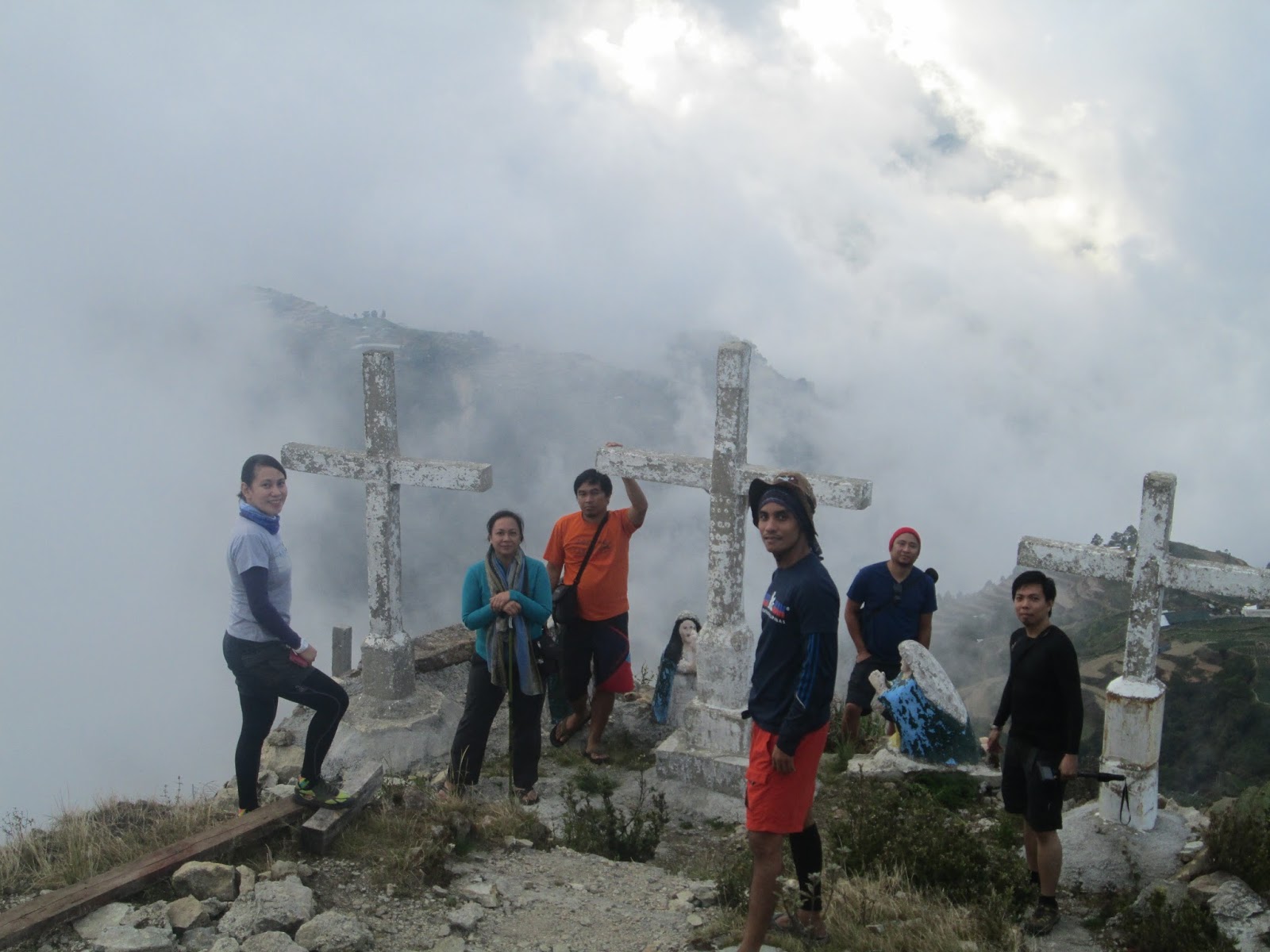
At the summit, unobstructed views of Mt. Pulag, Mt. Tabayoc, the town of Kabayan and the Kabayan-Abatan Road, vegetable terraces, rivers and other peaks may be enjoyed. Just a word of precaution, owing to the fact that the mountain is considered sacred by the tribes of the Cordillera, there are instances (especially during the burial of a person), when hikers are prohibited from venturing into the summit of Mt. Timbac. Moreover, I suppose that the summit area is private property since vegetable gardens are actually. prevalent there. As such, be considerate and mindful of the sensibilities and customs in the area.
 |
| That is the actual summit of Mt. Timbak |
 |
| The stonemarker at the summit |
 |
| And the clouds covered the peak while we were there. |
 |
| Skookums at the Summit of Mt. Timbac |
 |
| The plots are marked by hedges as boundaries. |
 |
| Hey watch out for those carrots!!! |
 |
| Psssttt....pogi. |
While we were aiming to hike from the highway at that time, the fact that we do not have a place to park our van made us decide to drive up until the last junction. Hence, we just enjoyed a leisure hike and have all reached the summit within thirty (30) minutes.
Traipsing Chronicles 031
012.013.015
Mt. Timbac / Singkalsa
Atok / Kabayan Benguet
Jump off point: KM. 55, Halsema Highway, Atok, Benguet
Minor Climb: 3/10 (from the Highway)
Highlights: Stations of the Cross; Magnificent Sunsets; Vegetable Terraces; views of Mt. Pulag, Mt. Tabayoc, and the rest of the Cordillera
Going There:
From Baguio City, hail a bus going to Sagada, Bontoc, or Buguias. Tell the driver to drop you off Km. 55 or better yet the road leading to the Timbak Fire Mummies of Kabayan. The jumpoff point is just along the Halsema Highway, just after the Highest Point in Cattubo (Atok,Benguet).
Guide. Guides are not really needed. Just follow the instructions above, or if you get lost, ask the people around and they will point your way leading to the Summit.
Registration. There are no registration fees in climbing Mt. Timbac / Mt. Singkalsa
 |
| Vegetable terraces |
 |
| Depicts Mt. Calvary |
 |
| Hey Skookum |
 |
| We are Skookum! |
Side Note***
We have also spent some time at the Highest Point of the Philippine Highway System in Cattubo, Atok, Benguet, which is located a few minutes from the jumpoff to Mt. Timbac. Dropping by this viewdeck is definitely a must for all those travelling in the Halsema HIghway.
 |
| Allan and Jaime |
 |
| Doc Eric |
 |
| Allan |
 |
| Bette and Oliver |
 |
| Bogs |
 |
| Engr. Gani |
Thanks guys for making Paskookum 2015 possible. Hope you attend the next Paskookum again.


No comments:
Post a Comment