“We were
not pioneers ourselves, but we journeyed over old trails that were new to us,
and with hearts open. Who shall distinguish?”
― J. Monroe Thorington, The Glittering Mountains of Canada: A
Record of Exploration and Pioneer Ascents in the Canadian Rockies, 1914-1924
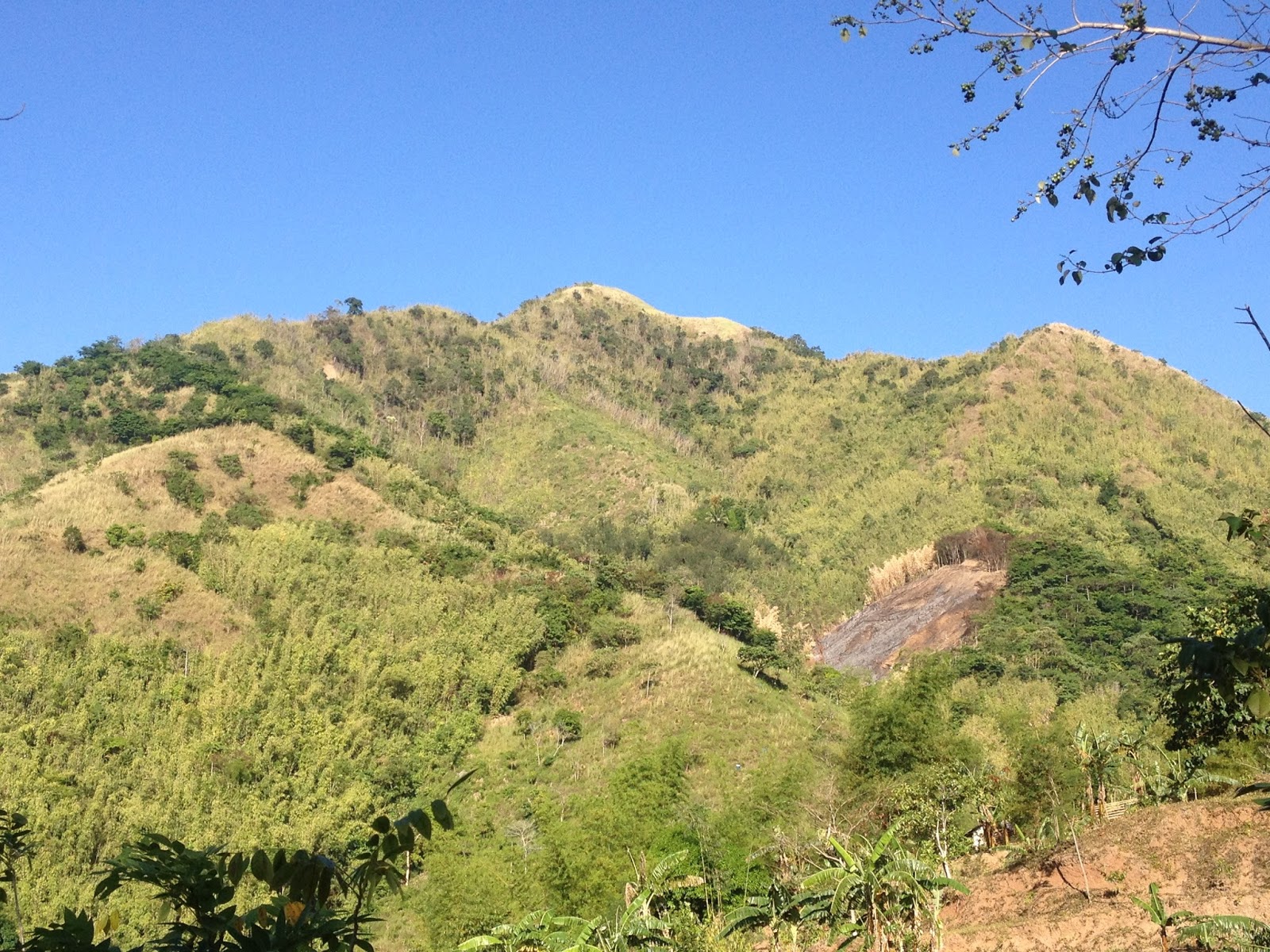
A new tramping ground has recently been launched in Tanay, Rizal. Dubbed as Maynoba Circuit, it was formally opened last March 22, 2016. And this early, I am sure that the Maynoba Circuit will soon be in the bucket list of mountaineers, hikers, climbers, and weekend warriors.
 |
| Mt. Maynoba |
 |
| Mt. Maynoba / Mt. Cayabu |
Climbing the Maynoba Circuit would entail climbing Mt. Maynoba and Mt. Cayabu. But the added bonus of having a chance to take a dip in any, if not all of the 8 waterfalls that may be found along the trail surely makes this climb undeniably enticing to everyone.
Having overslept (because I again dozed off after acknowledging the alarm that I have set), it was already 0545H when I arrived at the McDonald’s in Marco Highway to fetch my best hiking buddy (Gani). And after buying some of our needed provisions at a convenience store in Cogeo, we went straight to finding Brgy. Cayabu (Tanay, Rizal).
It was already 0720H when we arrived at Mar-ning’s Resort, the jump-off point for the Maynoba Circuit.
After paying the registration fees and securing our local guide for the day, we started hiking at 0745H. Thinking that what we are going to climb is the mountain opposite the resort, we were actually surprised when our guide led us towards the back of the resort.
 |
| Welcome to Mar-Nings Farm and Resort |
 |
| Swimming pool |
We initially hiked on rice paddies (one can actually survey the course of the hike here) until we reached the dirt path that eventually led to the “bamboo gate”. We then reached the
bohoan at 0800H.
While the initial terrain is mainly ascending, there are also some rolling parts that may serve as a breather for the harder climbs ahead.
 |
| Rice field at the back of Mar-Ning's |
 |
| Approaching the dirt path |
 |
The Bamboo Gate
 |
| Deeper into the woods |
|
 |
| Bohoan...locals use these to make sawali |
 |
| This "bulak" tree on the right side of the trail will signify the start of the assault to the Kakawate Ridge |
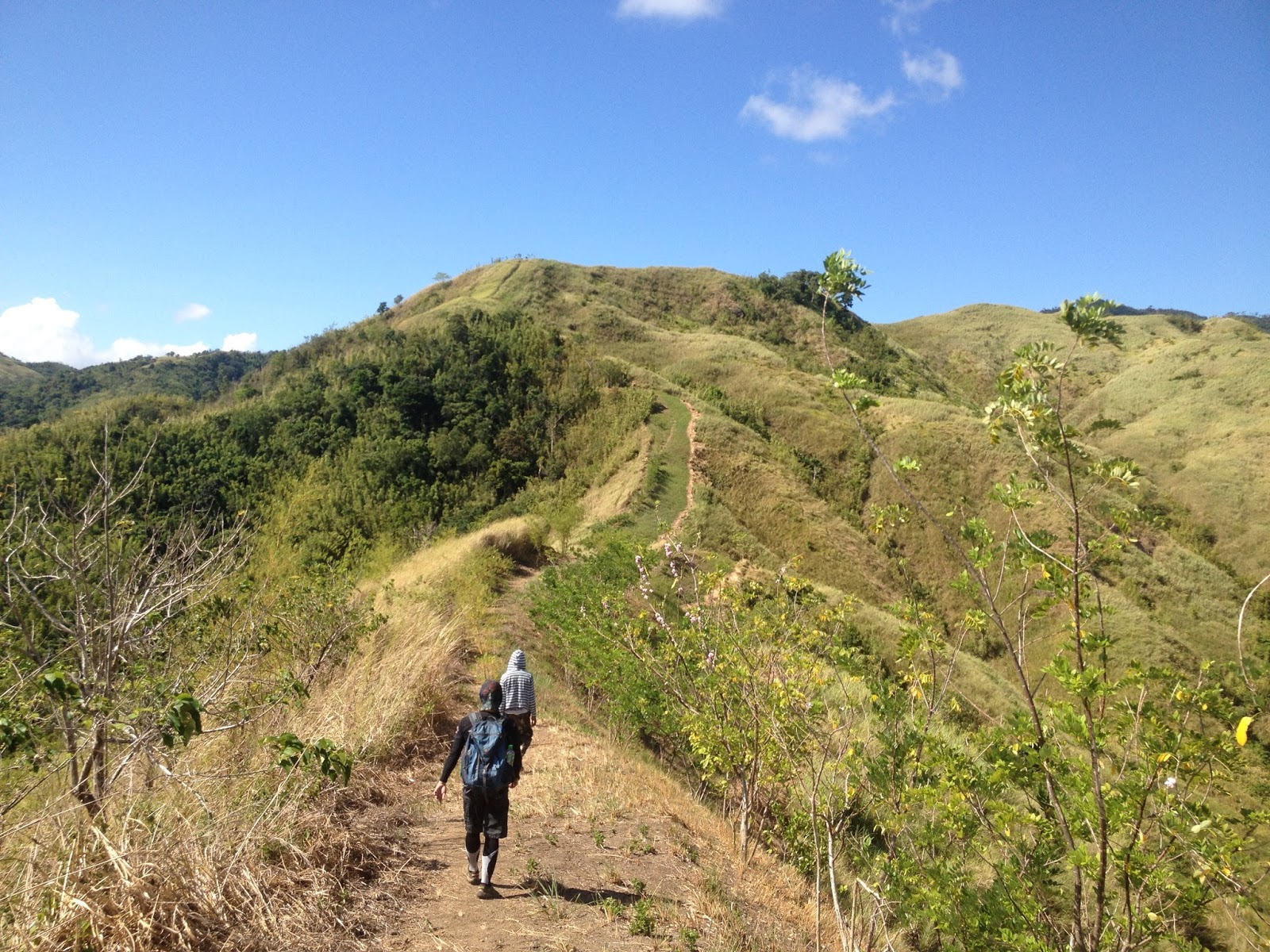
The bohoan will give way to an open terrain which also serves as the beginning of the unremitting climb to Kakawate Ridge (sorry I just coined this term because of the Kakawate Trees seen along the ridge). We were able to reach the Kakawate Ridge at 0840H. But because of the energy-sapping heat of the sun (courtesy of the Philippine Summer) we decided to spend some time there.
At 0855H we commenced hiking towards the summit of Mt. Maynoba to the left. Hiking along the Kakawate Ridge reminded us of Mt. Batulao and its magnificent views.
 |
| Open Trail with very few trees that will offer much needed shade |
 |
| Talahiban |
 |
| Kakawate Ridge...going to the peak on the right side |
 |
| Limited shade |
 |
| Enchanting view at the ridge |
 |
| Trail to the summit |
 |
| The white structure on top of the mountain opposite Mt. Maynoba is supposedly a camp of the SAF |
From the ridge, there is that one final assault towards the summit of Mt. Maynoba. This would be similar to the ascending climb to the Kakawate Ridge, albeit shorter. We finally reached the 1st summit (with the flag) (
I mentioned summit since this is what our guide told us) of Mt. Maynoba at 0915H.
 |
| Approaching the summit |
 |
| Thanks to the tree-planting activities of the DENR courtesy of the locals |
 |
| Final push to the summit |
 |
| Kakawate Ridge...the backview |
 |
| The mountains are calling. |
 |
| A sitio that is part of Antipolo already |
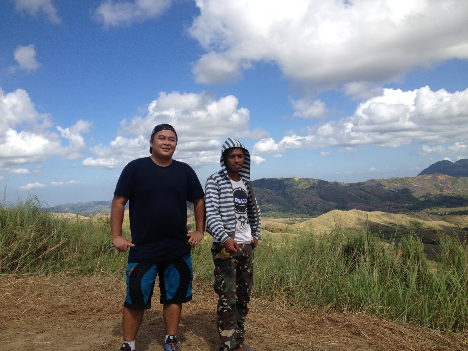
At the summit, we had an unobstructed view of the rest of Sierra Madre. Our guide (Ryan) pointed to us Susong Dalaga Peak in Mt. Batolusong, the resort owned by a famous singer-actress, and where Mt. Irid actually is. The summit also serves as a campsite.
 |
| Susong Dalaga Peak...on the far left |
 |
| The mountain resort of a famous singer-actress |
 |
| With our guide...Ryan San Juan |
 |
| Smiley |
 |
| The Flag |
 |
| Best friends...hiking buddies |
It was 0930H when we continued hiking towards Mt. Cayabu. Along the trail, we encountered two blue PVC pipes that supposedly serve as markers for the actual boundary of Tanay and Antipolo. The trail towards Mt. Cayabu is similar to the final assault to the Southern Summit of Mt. Sembrano. We reached the summit of Mt. Maynoba (
I have my reservations but our guide said that this is the summit of Mt. Cayabu, since it is just one contiguous mountain which necessarily has just one summit) at 0945H.
 |
| Tree Planting / Narra |
 |
| PVC Pipe / Borderline of Tanay and Antipolo |
 |
| Approaching Mt. Cayabu |
 |
| Mt. Maynoba Summit (Mt. Cayabu summit daw sabi ng guide namin) |
Mt. Maynoba’s summit, which is marked by huge protruding boulder in the middle also serves as a campsite. While it is actually more expansive that the campsite with the flag, the true summit of Mt. Maynoba has similar attributes with that of the former. Nonetheless, there are big boulders here where hikers may opt to do some buwis buhay and profile pic shots. The first set of boulders is located five (5) meters from the trail, while the other is just along the trail.
 |
| Hurray for Today! (Mt. Maynoba Summit) |
 |
| Boulder |
 |
| It ain't complete without a jumpshot! |
 |
| Wanna test my Kung Fu? |
 |
| Lonesome...in the sea of grass |
 |
| Smiley! |
 |
| Hang Loose! |
 |
| Boulders |
It was already 1010H when we left the boulders for the waterfalls. From here, the descent went on until we ultimately reach the forest. It was really a relief to finally have a natural shield from the rays of the sun. We ultimately reached the water source at the bohoan at 1025H. After briefly refreshing ourselves, we continued towards Natatagong Paraiso ("Hidden Paradise") Falls (1st), which we finally reached at 1030H.
 |
| From the boulders...we start to descend to the waterfalls. Yipee! |
 |
| Langka along the trail |
 |
| Kawayanan Water Source |
 |
| Natatagong Paraiso Falls |
 |
| Natatagong Paraiso Falls (Falls No. 1) |
 |
| It really is a hidden paradise. |
We left Natatagong Paraiso at 1110H and arrived at the Maykatmon Falls (2nd) at 1120. By the way, in going to the 2nd falls, we had to descend from the top of the waterfalls through its right flank. As we had the falls to ourselves, this is where we decided to have our dose of swimming. The water is really cold and refreshing.
 |
| We did a lot of bouldering as we tried to get to all the waterfalls |
 |
| May Katmon Falls (Falls No. 2) |
 |
| Refreshing |
We decided to leave Maykatmon for the Aynas Falls (3rd) at 1150H and arrived there after five (5) minutes. While this is one of the more impressive falls in the area, only the daring swim in its pool since it was supposedly deep. A few meters from here is the May Gugulong na Bato Falls (4th). Obviously, this falls was named as such by reason of the enormous boulder that seems to be on the verge of rolling over the falls. Judging from the number of persons there, I could say that this is actually a favorite spot for hikers to stay.
 |
| Aynas Falls (Falls No. 3) |
 |
| May Gugulong na Bato Falls, taken from Aynas Falls |
 |
| May Gugulong na Bato Falls (Falls No. 4) |
 |
| The reason behind the name "Gugulong na Bato". |
 |
| Bouldering galore |
A few meters downstream is the Maynoba Falls (5th). This is an area that is also good for swimming and photo-ops. There is a hut being constructed near this falls and our guide said that this is supposed to be a toilet. I just hope the locals would consider the impact of this toilet since it is located just 10 meters from it.
 |
| Maynoba Falls |
 |
| Maynoba Falls (Falls No. 5) |
 |
| The toilet, which incidentally is located very near the falls |
Next is the Lantay na Bato Falls (6th). While the area is not that impressive as compared to the others, this area is a good place to rest since there is a bamboo bench where people may stay. Besides, the thick canopy in the area would really be a welcome respite to the hot and humid surroundings.
 |
| Lantay na Bato (6th Falls) |
 |
| 6th |
 |
| The bamboo bench |
The Maybangka Falls (7th) is also a very good place for swimming. The pool is clear though deep in some parts. Hence, those who would elect to swim should exercise caution.
 |
| May Bangka Falls (7th Falls) |
 |
| The water is so inviting :) |
And finally, we reached the Magpantay Falls (8th) at 1210H. This is the smallest of all the waterfalls and is just a meter high. However, the water in its pool is very inviting. And since the waterfall itself is tucked between big boulders, this is also ideal for those who enjoy photo-ops.
 |
| Magpantay Falls |
 |
| Magpantay Falls (8th) |
At 1215, we finally decided to commence hiking back at the jumpoff point. We came into a pineapple plantation and there are a lot of hikers that chose to spend some time there. We made a series of river crossings until we reach the the covered spring that serves as the water supply of the people of Barangay Cayabu, which incidentally is located just after the huge balete tree. A number of river crossings again followed until we arrived at the local community and took a left turn towards the river and the “dam/pond” that we had to cross.
 |
| Pineapples |
 |
| Balete Tree |
 |
| enclosed Spring |
 |
| Crossing the dam / pond |
From here we emerged at the rice paddies at the back of Mar-Ning’s and finally arrived back at the jumpoff point at 1240H
**I have seen posts regarding the names of the falls in Maynoba-Cayabu Circuit. And some have different names for the falls from those mentioned in this post. Just to clarify, the names of the falls mentioned here are based on the information that we gathered from our guide (Mr. Ryan San Juan).
Traipsing Chronicles 035
004.024.016
Mt. Maynoba + Mt. Cayabu + 8 waterfalls
Brgy. Cayabu, Tanay, Rizal
Jump off point: Mar-ning's Farm and Resort, Brgy. Cayabu, Tanay, Rizal
Minor Climb: 3/9
Highlights: Panoramic view of the other peaks in the Sierra Madre; 8 water falls; bouldering; river crossings.
Actual Itinerary:
0530H - Departure from West Ave., Quezon City
0545H - McDonald's Marcos Highway / Purchase breakfast
0600H - Departure from 7-11 Cogeo
0720H - Arrival at Mar-ning's Farm and Resort
0745H - Start Hiking
0800H - Arrival at Bohoan
0840H - Arrival at Kakawate Ridge / Rest / Photo-ops
0855H - Commence final climb to Mt. Maynoba Summit
0915H - Arrival at Mt. Maynoba Summit (with the flag)/ Photo-ops
0930H - Left Maynoba Summit for Mt. Cayabu
0945H - Arrival at Mt. Maynoba (true summit) (Mt. Cayabu Summit according to our guide) / Photo-ops at the Summit and Boulders
1010H - Departure from the Boulders
1025H - Arrival at the Kawayanan Water Source
1030H - Arrival at Natatagong Paraiso Falls (1st falls) / Early Lunch
1110H - Departure at Natatagong Paraiso for Maykatmon Falls
1120H - Arrival at Maykatmon Falls (2nd falls) / Swimming
1150H - Departure from Maykatmon to Ayngas Falls
1155H - Arrival at Ayngas Falls and May Gugulong ns Bato Falls (3rd and 4th falls)
1200H - Arrival at Maynoba Falls (5th falls)
1205H - Arrival at Lantay na Bato Falls and May Bangka Falls (6th and 7th falls)
1210H - Arrival at Magpantay Falls (8th and last falls)
1215H - Departure for Mar-ning's / JOP
1225H - Arrival at the Spring / Bukal (enclosed) / Huge Balete Tree
1235H - Arrival at the Dam / Pond
1240H - Arrival at Mar-ning's / Back at JOP / Wash-up
1350H - Departure from Mar-ning's to QC
1520H - Back in West Ave., QC
Getting There:
Private Transportation
From Cubao LRT2 Station, take Aurora Blvd. East Bound and continue straight to Marcos Highway. You will pass by Sta. Lucia Grand Mall, Masinag, and Cogeo. After Cogeo, you will enter the Upper Marikina Basin Protected Landscape and traverse zigzag roads.
You will pass by Palo Alto and Garden Cottages. A few meters from Kilometer Post 51, the Welcome Arch to Barangay San Andres is on the other side of the road (left side). This is actually the place that locals refer to as Batangasan or Batangas.
Follow the road that will lead you to Brgy. San Andres. The concrete road will eventually turn rough. After Brgy. San Andres comes Brgy. Sto. Niño. Once you encounter the fork in the road, take the left side (upper road). The next barangay would be Brgy. Cayabu already.
Go past the Cayabu Elementary School and the Cayabu Barangay Hall until you reach the small concrete bridge. Mar-ning's Farm and Resort is located on the left side of the road just after the said small concrete bridge.
Early morning travel from Cubao to Brgy. Cayabu is 1 hour 30 minutes more or less. Traveltime from Brgy. Cayabu to Cubao (in the afternoon/early evening) is at least 1 hour 45 minutes because of the traffic.
Public Transportation
From Cubao, take a jeep or FX to Cogeo Gate 2 Antipolo (Php 35). Once in Cogeo, proceed to the jeepney terminal and take the jeepney going to Sampaloc/Tanay. Tell the driver to drop you off at Batangasan/Batangas. (1 hour travel time).
Hire a habal-habalor tricycle to Mar-ning's Farm and Resort in Barangay Cayabu. (25 minutes travel time). You can ask the habal-habal/tricycle driver to fetch you at Mar-ning's on your desired time. The drivers would sometimes ask for advance payment. The guides at Mar-ning's can also make arrangements with the tricycle drivers in the area.
Jeeps from Sampaloc/Tanay heading back to Cogeo Gate 2 usually pass by Batangas until 7pm (they leave Sampaloc at 6:30PM). Once in Cogeo, you can finally hail a ride (FX or jeepney) going to Cubao.
Guides. Local guides are mandatory and the prevailing guide fee is Php500.00 for a dayhike, which is good for five (5) persons. Overnight guide fee is Php1,250.00. Supposedly according to our guide (Ryan), there are only 26 guides in Cayabu. Hence, there are times (
and to think that this is just a newly opened mountain) that no guides are available anymore. So what they supposedly do is to advise the hikers to go to Batolusong or if ever there is one available, reserve local guides are also utilized.
For more information on this, you may contact Romar (President of the local guide association) at 0929 7658457. Please be advised that there signal in Cayabu is close to none. So it may take some time for him to reply. But usually, he may be contacted starting 1900H (07:00PM).
Registration Fee. There is a registration fee of Php20.00 per person to be paid at Mar-ning's.
Sea of Clouds. Yes, similar to nearby Mt. Batolusong/Rangyas Peak, it is possible to witness the Sea of Clouds phenomenon in Mt. Maynoba.
Climb Permit. Since Brgy. Cayabu lies within the jurisdiction of Tanay, Rizal, climbers/hikers who wish to climb Mt. Maynoba are supposedly subject to the rule that each climber must secure a permit first from the Tanay Tourism Office. However, in our case (similar to the time we climbed Mt. Batolusing (twice) and Mt. Mamara in Daraitan), we went straight to the jumpoff (Mar-ning's) and were allowed to hike even without having the supposed permit from the Tourism Office. But to prevent any hassle, kindly coordinate with the local guide association regarding this (check the number of Romar above).
Eatery. The store in Mar-Ning's sell cooked food. However, it is usual that they are yet to offer cooked food for breakfast. So to be safe, bring your own breakfast (trail food) or have your breakfast along the way before proceeding to Brgy. Cayabu / Mar-Ning's.
 |
| Registration Area / Eatery / Store |
 |
| Hikers arriving at Mar-Ning's |


hi po! ano po masl nito?
ReplyDeleteI am not really sure because of conflicting data that is available in the net. May nagsasabi kasi na estimated elevation is 720+masl at yung iba naman is 782masl.
Deletehmm...thank you po! :-) mga ilang hours po yung hike niyo to the summit at yung pagbaba niyo po?
Deletethanks ulit!
Ang paakyat po sa summit (yung may flag) is somewhere between 1 hr 20 mins to 1 hr. 30 mins. Kasi syempre sa photo ops po while on the trail. Then yung true summit po (2nd Summit) mga 15 minutes from the 1st summit.
DeleteDepende po ang pagbaba, mahirap po kasi mag-set ng oras dahil sa dami ng falls, madami ding photo-ops at ligo. Nadadagdagan ng oras sa IT. Kaya actual IT po ang naka-post.
Kung derecho po kayo at hindi man lang hihinto sa mga falls, mga 1 hour po depende sa pace nyo kaya makabalik sa JOP. Kung base kasi sa actual IT namin, 25 minutes from the last falls is nakabalik na kamisa JOP.
Ohhh...thank you po, dito po kasi next hike namin this coming June! :-D
DeleteBtw, na mention po ba yung difficulty dito? ano po?
Personally I would rate it 4/9. Medyo tricky po kasi ang trail sa pagbaba lalo na kung dadaanan nyo talaga lahat yung falls (susundan nyo yung mga falls kasi may ibang trail din po). Then may mga river crossing pero di naman kayo mababasa at talon na lang sa mga bato.
DeleteMaganda po dun Sir...ingat po...happy hiking!
Thank you po ulit! Naging helpful po itong website niyo and thanks sa pagsagot po! God bless!
DeleteWelcome po. :)
Deletewow salamat po sa blof na to.. Sir, yung way po ba papunta po dito iisa lang po papunta po sa Mt. batolusong? sana po makareply kayo...
ReplyDeleteHi Mam Lei, yes po. Yung daan po papunta sa Batolusong dun din po sya. Mga 4 kilometers po from San Andres yung Mar-Ning's. Sundin na lang po yung instructions sa post about getting there yun na po.
DeleteHappy Hiking!
Bale 7-8 kilometers po ang Mar-Ning's from Batangasan. Ang balita ko is P200.00 po yata ang singilan sa trike. Parang good for 4 ata. Di ko lang po sure kasi nagdala po kami ng sasakyan papunta dun.
Deletesalamat po sir... :) Happy climb po .. God bless...
Deleteconfirm ko lang po sir kung ganito
ReplyDeletejeepney from Cubao to Cogeo gate2
jeepney from Cogeo gate2 to Batangasan
tricycle from Batangasan to marning's resort ..?
Yes mam...tumpak...tama po. :)
Deletesalamat po...
Delete24 hours po ba ung jeep from cogeo to batangasan?
DeleteHindi po...ang alam ko po 1st trip Cogeo to Sampaloc mga 5:00am... at last trip from sampaloc to cogeo is 6:30pm. So mga 7:00pm sila aabot sa Batangasan
DeleteGoodaft!, may need ba iSecure na permit/s prior to climb? Thanks!
ReplyDeleteGood Pm Sir, nung umakyat kami deretso na kasi kami sa Cayabu / JOP pero di naman kami hiningian ng permit. Nagbayad lang kami ng registration fee at nag-secure ng guide.
DeletePero sa pagkaalam ko Sir, kapag dumaan kayo sa Tanay Tourism eh hahanapan kyo ng permit o may submit pa kayong mga requirements sa kanila para ma-process ang permit nyo.
so ung permit di naman mandatory? makakaakyat pa rin po kahit di magsecure ng permit basta may guide? tama po ba? thanks.
ReplyDeleteKung ang kausap nyo po kasi eh taga Tanay Tourism, sasabihin nila required ang permit. You may refer to my previous post regarding this.
Deletehttp://skookummountaineers.blogspot.com/2015/07/tanay-tourism-issues-requirements-for.html
Pero ilang beses na po kasi ako umakyat sa Tanay (twice sa Batolusong, sa Daraitan (Mamara), at sa Maynoba, lahat walang permit, deretso po kami sa jumpoff parati pero pinapaakyat pa rin naman po kami. Di naman nila kami hinahanapan ng permit.
Kung gusto nyo mam para klaro kontakin nyo po mga guides sa Cayabu. Kung wala pa po kayo kontak bigyan ko kayo. Happy Hiking!
Sir,pag overnight. Need pa ba ng permit?
DeleteHindi po ako sure sir. May mga nagsasabi kasi na kailangan nga daw ng permit pag overnight. Dayhike lang po kasi kami sa Maynoba. Paki-kontak na lang po mga guides sa Cayabu. Please refer na lang po sa numbers posted somewhere sa comments.
DeleteThanks po.
Eto po sir. Si Romar po ang President ng guides sa Cayabu. Si Ronald naman ang Vice President. Happy Hiking Sir!
ReplyDeleteRomar Anito: 09297658457
Ronald Africano: 09084430444
waw, sir.
ReplyDeleteang bilis.
mababa lang po talaga yung bundok?
parang Tagapo or Gulugod-Baboy lang po pala.
1-2hrs papuntang summit.
helpful po. salamat.
More on Tagapo Sir....pareho din na open ang trail sa taas kaya dapat maaga kayo or magbaon ng sapat na tubig kasi after ng summit pa yung water source. Depende kasi ang pacing nyo sa oras na gagamitin sa pahinga at picture taking na din. Kung normal pacing kahit 1hour 30 mins kaya. Happy Hiking!
DeleteSir tanong lang po. Pwede po bang overnight? Magkano po kaya ang budget?
ReplyDeleteHi Mam, pwede po. May mga pwedeng campsite sa taas although mga 30 minutes from the campsite pa yung water source.
DeleteKung sa budget, depende po kung ilan kayo. P1250 ang bayad sa guide for overnight. So kung lima kayo, P250 each yun. Pag dayhike kasi is P500.00 ang guide for 5 hikers.
Sa tantya ko, safe budget po ang 600 - 700 kasama na meals for overnight. Pero syempre ibang usapan kung may organizer kayo o tour operator.
Happy Hiking Mam!
Noted Sir. Maraming salamat po. :)
DeleteSir, question po. Di ba lampas yung Marning's Resort sa jump-off papuntang Batolusong? Diretso lang po ba sir after sa jump-off ng Batolusong? Tapos left side? Alam ko po wala sa google maps yung Marning's pero sir baka makapagbigay kayo ng coordinates. Pupunta kasi ako via private transpo. Baka mawala ako. Haha Salamat ng marami Sir.
ReplyDeleteTama po sir. Mula sa JOP ng Batolusong, deretso lang kayo. Sunod po dun eh yung Brgy. Sto. Nino. Kapag narating nyo yung parang junction, dun po kayo sa kaliwang daan (pababa po yung kanan which is papunta sya sa ibang parte ng Sto. Nino).
DeleteDeretso na lang po yun hanggang sa madaan nyo yung school, brgy. hall, tapos deretso pa ng kaunti pagkatapos ng tulay na maliit, Mar-Niong's na po yung sa kaliwa. May kubo po sa may pagkatapos ng tulay sa may gate ng Mar-Ning's
Happy Hiking Sir!
pwede ba overnight?
ReplyDeletePwede sir...P1250.00 ang guide fee kapag overnight. Maayos naman ang campsite sa may summit.
Delete1,250 talaga guide fee. mahal pala. tapos kapag 10 kaya so need ng 2 guides?
DeleteYes po...pero ang balita is nagkakaubusan ng guides kapag weekends...so kung sakali makiusap kayo baka payagan kayong isa na lang ang guide.
DeleteHi! Just want to ask kung pano kumuha ng permit? Sabi kasi need daw ng permit pag magovernight?
ReplyDeleteSir, hindi po ako sure kung kailangan nga ng permit kapag overnight. Paki-verify na lang din po sa mga guides sa Cayabu kung sakali. Pero kung kukuha po kayo ng permit, paki-contact po ang Tanay Tourism sa mga numbers na nasa baba.
Delete0917.5229024 / 0936.2284173 / 7361059 or 0998.9881590
Eto po baka maktulong din
http://skookummountaineers.blogspot.com/2015/07/tanay-tourism-issues-requirements-for.html
Hello! This blog is so helpful. Can I ask if how much is the parking fee?
ReplyDeleteHi Sir, parking is free when we went there. I am not sure now if payment of parking fee is already required in Mar-Ning's.
DeleteHappy Hiking!
Hi! May ibang number po ba kayo ng guide? Hindi kasi namin macontact yung number na nakapost. Thanks!
ReplyDelete- Gwen
Hi Mam Gwen, try nyo po sila tawagan ng mga 7:00PM onwards....mahina at madalas sadyang wala po signal sa Cayabu. Although sige po mam, try ko din po magtanong sa mga kakilala ko kung may iba pa silang contact para sa Maynoba.
DeleteKung may FB po kayo, pwede nyo rin po i-PM si Ronald Africano...VP po ng samahan ng mga guides.
Ask lng mga sir. Compared to Mt. Batolusong, sino po mas madali akyatin? Based on your photos, parang gradual lng ung ascend. Thanks sa reply.
ReplyDeleteHi Sir, halos pareho lang. Pero personally I would say na parang mas mahirap nga ang Batolusong akyatin kung isasama yung Rangyas Peak. Pero medyo konti lang ang difference talaga.
DeleteSa pagbaba, kung dadaanan nyo yung lahat ng mga falls tapos dun kayo sa bouldering trail, mas mahirap po ang Maynoba. Sa Batolusong kasi, medyo ok ang pababa pa-traverse ng Kay-Ibon.
All in all, halos pareho lang po talaga. Happy Hiking!
Ask lng mga sir. Compared to Mt. Batolusong, sino po mas madali akyatin? Based on your photos, parang gradual lng ung ascend. Thanks sa reply.
ReplyDeleteask lang po for overnight campers what to expect po? campsite condition?
ReplyDeleteMaayos po ang mga campsites. Mas maluwang yung 2nd campsite at mas malapit din sya sa water source. Medyo ingat lang sa apoy at talahiban kasi ang immediate vicinity. May chances ng sea of clouds in the early morning, tsaka maganda para sa stargazing sa gabi kasi open talaga ang campsite, which also means dapat maaga ang break camp at mainit talaga kahit na mga 8:00am pa lang.
DeletePwede po ba unahin yung mga falls bago mag proceed sa summit or camp site?
ReplyDeletePwede po mam. Depende na po sa inyo yun kung reverse circuit ang gusto nyo. Pero sa tantya ko mas mahirap ang pag-akyat kapag ganon po na uunahin nyo ang falls. Pero kaya naman po sya.
Deletesalamat po sir..
ReplyDeleteVery informative blogging! Thanks!
ReplyDeleteVery informative blogging! Thanks!
ReplyDeleteMga what time po dabest para sa sea of clouds?
ReplyDeleteBasta dapat before sunrise (more or less 5:00am) dapat nasa summit na po kayo to have better chances. So depending on your pace, more or less dapat 3:00am to 3:30am ang start ng hike.
Deletehi po.. ask ko lang po. if open ang registration area kapag start ng trek ng 2am or 3am? and also sa securing ng guides po?
ReplyDeleteOpen po...basta mas maganda po kung makipag-coordinate kayo in advance para alam din nila. Marami na po umaakyat ng madaling araw doon.
ReplyDeleteHappy Hiking!
sir safe po ba sa bata kahit maulan po?
ReplyDeleteYes po mam basta ingat na lang po kung pababa na kayo lalo na rin sa may mga falls at bouldering.
Deletemagkano po yung guide pag overnight?
ReplyDelete1250 po mam
Deletegood for 5 lang un? pano po pag 10 kami? need ng 2 guides, so 2500 na?
ReplyDeleteApparently yes. Hindi ko lang po kasi sure kung papayagan kayo ng isang guide lang. Better to clarify this with the guides. Ang alam ko po kasi is allowed nila hanggang 7 hikers per guide. Hindi ko lang po sure kung may nagbago sa patakaran nila ngayon.
ReplyDeleteSir, may sakayan po ba sa shaw (starmall) papuntang Cogeo? or pwede po ba kami sumakay sa shaw (Starmall) byaheng tanay? saan po kami bababa?
ReplyDeleteAng alam ko po wala. Kung sa Shaw po kayo manggagaling, sakay po kayo papuntang Tanay. Kapag nasa Tanay na po, sakay kayo ng tricycle papuntang Sampaloc. Kung madami po kayo, tanungin nyo yung jeep kung gusto nya ihatid na kayo derecho sa Sampaloc. medyo mabagal dini kasi ang byahe kapag tricycle pa kayo. Sa Sampaloc junction, sakay po kayo ng papuntang Batangasan. Sa Batangasan, habal-habal na po kayo papuntang jump-off.
DeleteSir, kaya po ba ng vios yung daan ppnta sa drop off? Thanks.
ReplyDeleteSa tingin ko sir kaya po kasi City po yung gamit ko. yung rough road naman po kasi eh patag naman at hindi sobrang maputik. Di lang po ako sigurado ngayon kasi tag-ulan pero sa tantya ko po hindi naman sya ganun magpuputik kasi nga di naman malambot lupa sa daan.
DeleteKapag pabalik na po kayo galing Maynoba paakyat sa highway, may matarik po na akyatin kaya siguraduhin nyo lang po na nasa kundisyon ang sasakyan nyo. Happy Hiking po!
Sir, kaya po ba ng vios yung daan ppnta sa drop off? Thanks.
ReplyDeleteThanks for your blog sir. Gusto po namin itry akyatin. So yung bayad sa guide po 500 per 5 persons? Tapos need pa talaga ng permit sa tanay tourism kahit dayhike lang po?
ReplyDeleteAs for the guide fee, yes sir P500 for 5 pax. With regard to the permit, paki-clarify na lang po sa guides. Pwede nyo po sila kontakin. Kasi nung kami po umakyat, di na po kami hinanapan ng permit. Ayoko naman po sabihin na di na kailangan kasi nga ang alam ko may ordinansa yata tungkol diyan.
DeleteSa ibang parte rin po kasi ng Tanay, pinaaakyat naman kami kahit walang permit. Basta pipirma daw ng waiver. Kaso madalas wala naman pong waiver na pinapapirma sa amin.
Eto po...pwede nyo po kontakin ang President at VP ng mga guides to confirm kung kailangan pa ng permit from Tourism Office para sa dayhike.
DeleteRomar Anito: 09297658457
Ronald Africano: 09084430444
Sir may sea of clouds din po ba dito?
ReplyDeleteMeron po sir. Pero dapat maaga po kayo. At the latest mga 4:00-4:30am dapat start ng hike para maabutan nyo ang sea of clouds.
DeleteThanks for your blog sir. Gusto po namin itry akyatin. So yung bayad sa guide po 500 per 5 persons? Tapos need pa talaga ng permit sa tanay tourism kahit dayhike lang po?
ReplyDeleteHi Sir, ask ko lang kung kaya ng motor ang byahe and baka pwede ka mag-provide ng exact way for private vehicles.
ReplyDeleteSalamat
https://www.google.com.ph/maps/place/Mt.+Maynoba+Jumpoff/@14.6653838,121.3397568,17z/data=!3m1!4b1!4m5!3m4!1s0x339796c60f9dd417:0xe9082da53e0abc0c!8m2!3d14.6653786!4d121.3419455
DeleteSir check mo yung link. Pwede din i-streetview yan para makita yung daan :)
Kayang kaya po ng motor Sir/Mam papunta sa Maynoba. Siguraduhin nyo lang na kundisyon ang motor nyo kasi matarik po yung paakyat kung pabalik na kayo sa Highway pauwi.
DeleteAs to the "exact way", nasa post po Sir/Mam. Check nyo po yung "Getting There" tapos nasa "Private Transportation" po. Kung medyo nalilito po kayo or kailangan nyo ng ibang directions kasi iba panggagalingan nyo...comment lang po.
chief....ask ko lang, pag traditional trail, may river cross ba? Salamat
ReplyDeleteMeron po Kap. Yung pagdating sa unang falls...although bouldering po sya. Sa pagbaba din galing sa huling falls pabalik ng JOP may mga river crossing din. Di ko lang po alam kung gaano kataas ang tubig dun kapag tag-ulan.
Deleteask ang po what time po start ng dayhike? if for example we will start to trek at 3 or 4am counted po ba ng onyt hike un?
ReplyDeleteHi Mam / Sir...hindi po. That will still be considered as a dayhike. Karamihan po talaga ng may plano makakita ng sea of clouds eh 4am-5am ang start ng hike.
DeleteHello Sir~!
ReplyDeleteGaling po ng blog nyo very detailed po ^_^ my cousins and I are planning on a dayhike but DIY itinerary po kami. If we start climbing po as early as 4 AM, do we need head lamps or flash lights? Are guides, jeep and tricycle available as early as 4 AM sir?
Maraming salamat po in advance ^_^
Hi Mam April,
DeleteThanks po sa compliments. I really make my posts as detailed as possible since DIY din ang mga hikes namin.
Yes po mam. If 4am kayo mag-start, need po definitely ng headlamps / flashlights. I am not sure po kung may nagpapa-rent sa jumpoff kasi nung umakyat kami dun parang 1 week pa lang yata na nagbukas ang trail kaya di pa po ganon karami ang madaling araw ang hike. Pero ngayon tiyak marami po kayo makakasabay sa trail kahit na madaling araw ang start nyo.
Guides po available anytime...pero advise ko po kayo to contact yung mga guides...either yung President o yung Vice....para rin po makasiguro kayo na may naka-reserve sa inyo.
Yung jeep po sa Cogeo to Batangasan, I believe mga 4am to 5am po start ng pila. Hindi ko lang po sure kung may pumipila na dun ngayon ng mas maaga pa dun kasi nga marami po talaga ang umaakyat ngayon sa Tanay. Yung tricycle, di din po ako sure, pero sa tingin ko po mam marami na nagaabang sa Batangasan ngayon kahit na madaling araw at naghihintay ng hikers. Dun din po kasi ang daan papunta sa Mt. Batolusong. Sorry po at nagdadala kasi ako ng sasakyan kapag hike at bihira mag-commute. Yung mga alam ko po kasi eh nakukuha ko lang din sa mga guides at mga locals sa registration / jumpoff.
Pwede nyo po i-clarify yung ibang details like jeep / tricycle sa mga guides kapag nakontak nyo sila. Eto po numbers nila....kapag out of reach...try nyo po mag-txt kasi walang signal sa Cayabu...di ko lang po alam ngayon kung ok na ang signal dun.
Romar Anito: 09297658457
Ronald Africano: 09084430444
Happy Hiking po Mam!
Hi! First time kong magtetrek with bestfriend. Itatanong ko lang kung required po ba talaga ang kumuha ng guide or pwedeng sumabay nalang sa mga aakyat din? Medyo kapos kasi kami sa budget eh hahaha gawa ng puro celebratrion this past few days. Thank you and God bless!
ReplyDeleteHi Nathan, required talaga ang guide sa Maynoba. Suggestion ko, kumausap na lang kayo sa ibang hikers kung pwede kayo sumabay sa kanila para makatipid sa guide fee. Marami naman umaakyat sa Maynoba, pwede kayo mag-abang sa jump-off ng hikers o kahit sa may Batangasan or sa Cogeo kung commute kayo.
DeleteMababait naman ang karamihan ng hikers at accommodating naman sila sa mga baguhan. Explain nyo na lang po na gusto nyo din makatipid. I'm sure matutuwa din sila kung makakatipid din sila kahit paano.
Happy Hiking Sir!
Open siya every Sunday. aakyat sana kami. Baka kasi close siya or under rehabilitation. Hindi naman diba?
ReplyDeleteYes po mam. Wala pa naman ako nakitang update na under rehabilitation sya. Pwede nyo rin po i-confirm sa mga guides kung may update sa Maynoba. Eto po numbers ng President at Vice nila:
DeleteRomar Anito: 09297658457
Ronald Africano: 09084430444
Happy Hiking!
Hi ask lng po my parking area po b sila sa jump off.? And safe nmn po b if ever mgpark. Thanks po planning to climb on feb.
ReplyDeleteHi Monskie. Yes po mam. Meron po parking area sa Marning's (JOP) at safe naman po sya kasi fenced area naman yung resort. At lagi naman pong may bantay dun. Kapag marami rin umaakyat, nakatambay lang dun yung mga guides.
DeleteHappy Hiking po mam!
I think I know who is the famous singer actress you are referring to. Haha! We climbed yesterday at Mt. Batosulong and our guide told me about her and her place there. I just forgot to ask our guide kung saang barangay yung farm nya dyan sa rizal 😁
ReplyDeleteSakop po yata ng Brgy. Cayabu yun hehe.
DeleteHello, Sir.
ReplyDeleteSan po kayo nag park nung pumunta kayo doon?
Hi Sir / Mam,
DeleteSa loob na mismo ng Mar-Ning's na rin po kami nag-park. Malaki at may bakod naman yung area kaya safe na po sasakyan dun. Dun na rin po sa Mar-Ning's ang registration at jump-off.
Happy Hiking po!
hi po.. what if hnd po macontact ung sa guide para maconfirm kung pwede maghike o hnd salamat
ReplyDeleteHi Kat...As of the last info I receied, ok pa naman ang walk-in sa kanila...so pwede po kayo derecho sa Mar-Ning's / jump off.
DeleteNung kami kasi ganon din po ang ginawa namin. Walk-in lang kami. Ang hassle lang po dyan kasi mam eh baka sa dami ng umaakyat eh wala na maibigay na guide sa inyo.
Happy Hiking!
Hello! May parking area po ba?
ReplyDeleteYes po Sir...meron po sa may jump off mismo sa Resort.
DeleteAng ganda. Is it ok for beginners? May mga wall and rock climbing po ba?
ReplyDeleteOk po sya sa beginners. Wala naman po wall or rock climbing. Maliban dun sa pababa sa may papuntang falls, wala naman na po technical sa trail
DeleteHi pwede po ba mag camping overnight sa mar-nings thank you
ReplyDeletePwede po b mgcamp sa mar nings overnight?
ReplyDeleteYes, pwede po.
Delete