– Ralph Waldo Emerson
After almost two years, we were finally back in Wawa to explore the mountains that were newly opened as hiking destinations.
Commencing the hike at 0720H, we threaded the road leading to Mt. Parawagan. We were initially surprised to see that the dirt road has now been cemented up to the point where a public resort is located just a few minutes before the junction leading to Mt. Lagyo is located. As there was an on-going fun ride at that time, we had to contend with a considerable number of riders making their way to the summit of Mt. Parawagan.


As it was Engr. who scouted for our hike and prepared our itinerary, we were then expecting a leisurely hike. Nonetheless, through the prodding of our guide (Mang Geovanni), we were persuaded to traverse Mt. Lagyo onward to Mt. Susong Dalaga for a twinhike.
It was already 0800H when we reached the junction where we bid farewell to the bikers and continued towards Mt. Lagyo. It was after we reached another junction (where we took the trail on the left...the path on the right leads toward a residential area) that the trail began to get steeper. A mountain biker followed us and asked for directions saying that he is going to Pintong Bukawe which is still at least 3-4 hours from Mt. Lagyo (depending on the pace) considering the terrain of the trail that he still needs to cover. From the said junction where a store is located, we had to circle around Mt. Lagyo until we finally reached the trail that leads to the upper portions of the mountain.


It was 0820H when we reached the trail at the base of Mt. Lagyo where we decided to have some time to catch our breathes and prepare for the steeper climbs ahead. Initially, banana and some fruit-bearing trees dot the trail, until the rock scrambling began. Then we reached a bamboo grove which ultimately gave way to some more rock scrambling. The hike went on until 0915H, we reached the general area where the 1st Peak (viewdeck) of Mt. Lagyo is located.


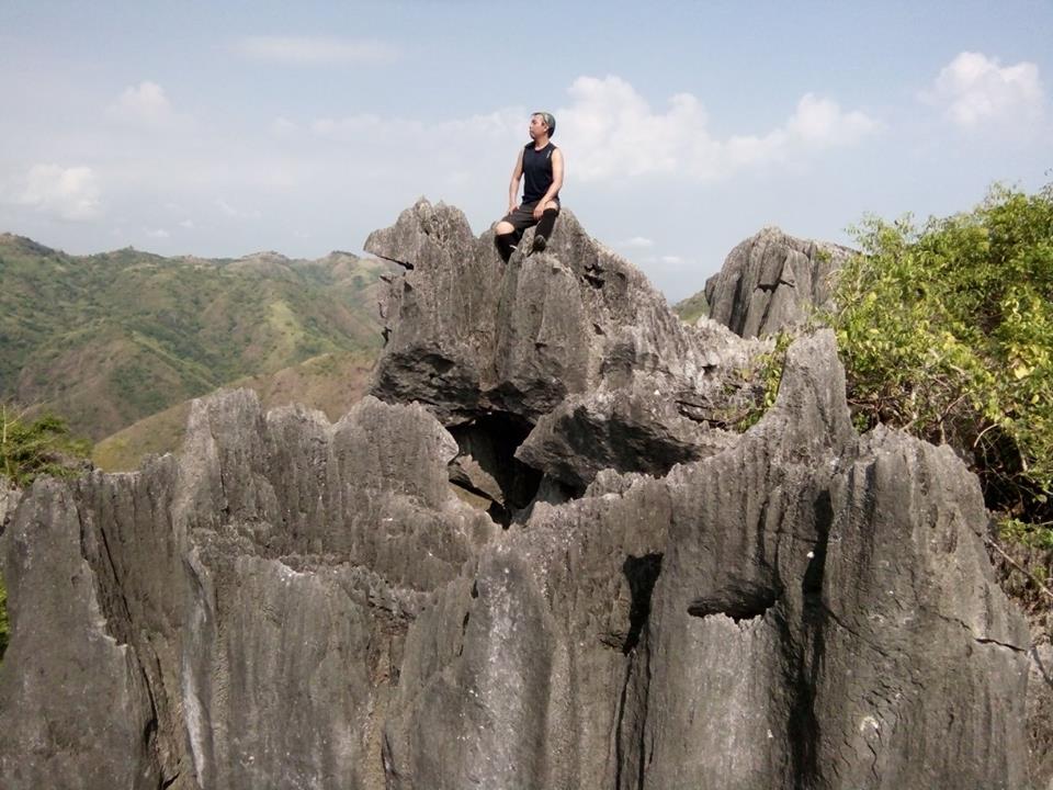
From the main trail, one has to to do another series of rock scrambling / bouldering. At Peak 1, one may choose to stay within the confines of a robust tree for shade, or explore the area which is really good for photo ops. Here, we were treated to magnificent views of the Sierra Madre.
 |
| More rock scrambling to reach Peak 1 |

 |
| Go...go...go |
 |
| Taaadaaa! Peak 1 at last! |
 |
| Ok...jagged rock formations |
 |
| Careful now. |
 |
| Peak 1 |
 |
| Taking a breather. |
 |
| Haaahaaa |
Moving forward, a few minutes from the trail leading to Peak 1 is a giant Banyan Tree (Balete). This part of the trail is just one of the very few rolling terrain that hikers will encounter in Mt. Lagyo. A few minutes from here is the junction leading to Peak 2. Nonetheless, we decided not to go there anymore and just continued hiking towards the Summit.
 |
| Balete Tree |
 |
| Alagad ni Vajullah |


This viewdeck below the Summit Area is a nice place to do some photo ops. While the Summit is clearly visible here, we still had to negotiate through vertical walls and crags, and go around such base. It was already 1000H when we finally reached the summit of Mt. Lagyo.

 |
| Easy now! |
 |
| Daredevil |
 |
| Vertical wall climbing....below is the trail coming from Mt. Susong Dalaga |
 |
| Hingal pa....konti na lang |
 |
| At the summit....finally! |

 |
| Jumpshot...at the Summit |
We followed the steep descent towards the Susong Dalaga Trail by carefully negotiating the straightforward path to the dirt road below, which we have eventually reached after 20 minutes of continuous hike. We followed the road until we finally reached the fork that led us towards Mt. Susong Dalaga.
As its name suggests, Mt. Susong Dalaga was so-called by reason of its iconic shape, that is of a maiden's breast. The initial trail was relatively easy until we reached the grassland that eventually led us to the very steep ascent to its peak. This steep incline would actually make it harder for climbers reach the summit during the rainy season.
Upon reaching the summit of Mt. Susong Dalaga, we were surprised to see a mysterious hole, which based on our experience
 |
| May butas sa tuktok ng Mt. Susong Dalaga! Sabi nga ni Mang Geovanni (guide namin)....tinaggal daw ang utong heehee |
Tramping Chronicles #043
004.023.017
Mt. Lagyo traverse to Mt. Susong Dalaga
Jump off point: Sitio Wawa, Brgy. San Rafael, Rodriguez, Rizal
Minor Climb: 4/10
Highlights: Limestone Formations; Rock Scrambling / Bouldering; River Trekking; panoramic views of the Sierra Madre Mountain Range (Mt. Binacayan, Mt. Pamitinan, Mt. Hapunang Banoi, Mt. Parawagan, Mt. Ayaas, Mt. Irid and Mt. Tukduang Banoi) and the Metro Manila Skyline; in some instances Sea of Clouds.
ACTUAL ITINERARY
0500H - Meet-up at McDonald's Centris (EDSA Northbound)
0520H - Depart for Rodriguez, Rizal
0620H - Arrival in Sitio Wawa, Rodriguez, Rizal / Register / Pays Fees / Secure Local Guide
0645H - Departure to the end of the Concrete Road / Resort
0655H - Arrival at the resort / Park Vehicle along the road
0720H - Commence Hike
0740H - Arrival at Lagyo / Parawagan Junction
0750H - Arrival at the foot of Mt. Lagyo / Residential Area Junction
0810H - Arrival at the fork where the trail leading to Mt. Lagyo is located / Rest stop
0830H - Continued Hiking
0855H - Arrival at the 1st Peak / Explore / Photo ops
0920H - Continued Hike to Summit / Final ascent to Summit
0930H - Arrival at the huge Balete Tree before the Bamboo Grove
0940H - Arrival at Junction to 2nd Peak / Continued towards Summit
0950H - Arrival at the viewdeck / Summit Area / Rest stop / Photo ops
0955H - Commenced rock scrambling / wall climbing to Summit
1010H - Summit / Photo ops
1030H - Back at the viewdeck / Descended the steep trail towards the dirt road below
1045H - Arrival at the dirt road / turned left towards Mt. Susong Dalaga
1055H - Arrival at the fork leading to Mt. Susong Dalaga
1110H - Arrival at the Summit of Mt. Susong Dalaga / Photo ops
1120H - Descended Mt. Susong Dalaga through the River Trail (very steep trail)
1130H - Arrival at the dried up river / Followed the river downstream
1140H - Arrival at the local's Hut / Rest stop
1150H - Arrival at another local's hut / Bought fresh coconut water / Indulge in coco water
1200H - Commenced Hiking
1210H - Arrival at the Residential Area / Resettlement Area for the locals
1220H - Back at the end of the concrete pavement
1230H - Back in Wawa / Lunch / Wash up
1330H - En Route back to Metro Manila
1420H - Back in Quezon City
Similar to the other peaks in the Wawa area, one should be extra careful in negotiating jagged rocks as well as prepared to do some vertical wall climbing.


Love this 🥰
ReplyDelete