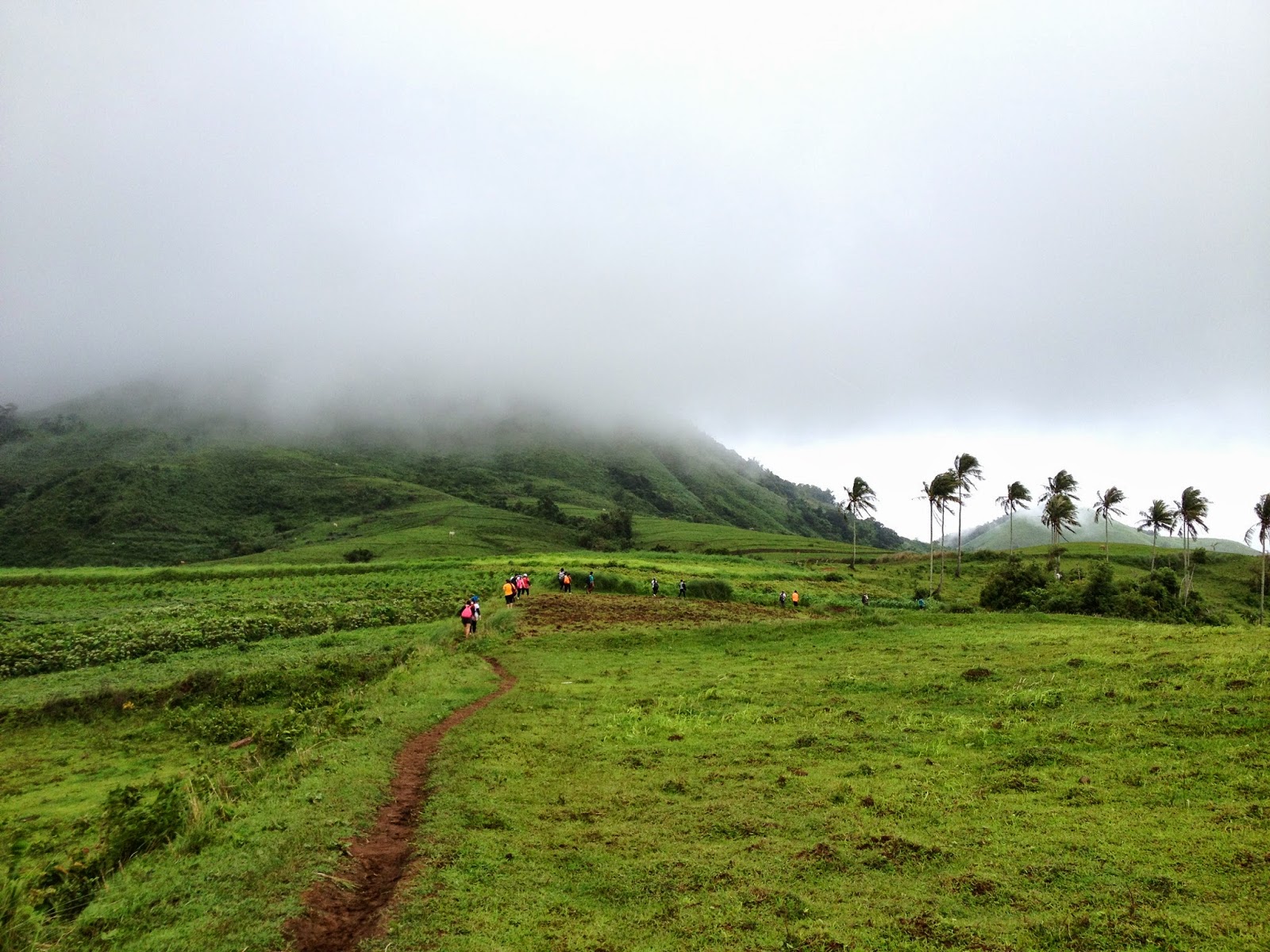
Since we scrapped our planned dayhike at the San Jose Circuit last Saturday (September 20) due to the inclement weather brought about by Typhoon Mario and the enhanced Habagat, we decided to do a "substitute hike" at Mt. Pico de Loro last Sunday (September 21). Although it was really some spur of the moment decision, the thought that there would be less hikers there (hence a better chance for us of scaling the fabled "Monolith") made us oozing with adrenaline.
We left Quezon City at 0500H and had to fetch Gani at the Boni MRT Station along EDSA. Passing through the Coastal Road and Cavitex, we finally reached the DENR Station along the Ternate-Nasugbu Highway in less than 2 hours. We could have arrived earlier because while the traffic at that instance was still bearable, we were somewhat delayed as we neared the jump-off point since there were road repairs at the approach of the Magnetic Hill.
We then immediately prepared our gears, paid the registration fee of P25.00 and proceeded to the nearby store cum eatery for breakfast. While they did not prepare pre-cooked meals because they anticipated that mountaineers will only come in trickles, they still have on hand silog meals.
It was already 0745H when we left the DENR. Of course, we prayed at the trailhead like we were accustomed to. As we also did some stretching exercises, it was already 0755H when we formally started to hike.
We traipsed leisurely at the start as we were welcomed by chirping birds and the whistling of leaves. It really is a very welcome respite from the intoxicating life in the city. The forest in Mt. Pico de Loro is really very impressive.
At 0815, we arrived at the famous "orange tree" (it was not an actual "orange" tree but I called it as such because its bark has this somewhat orange glow) where we encouraged Gani to have a picture. At the junction where one needs to do a right turn (going to Camp 1), we noticed the trail sign made up of luminous Mountain Dew plastic bottles that one of the vendors at the DENR mentioned to us. We then passed by the famous fallen tree trunk, and was able to reach Camp 1 at 0825H.
Friday, September 26, 2014
Tuesday, September 2, 2014
Mt. Gulugod Baboy / Mt. Pinagbanderahan - Tramping the famous "Pig's Spine"
We left Quezon City at 0420H bound for Anilao, Mabini, Batangas, one of the most recognized diving sites in Philipiines. But we are in for a different adventure and that is to scale Mt. Gulugod Baboy, so-called for its resemblance to a "pig's spine". There were actually five of us who answered the challenge for this climb.
We arrived at the scenic town of Mabini, Batangas at 0630H and went straight to the market for breakfast and for us to buy some provisions. And after having our fill of Pork Nilaga, Liempo, and Giniling, we headed straight to the PhilPan Dive Resort in Anilao, the jump-off point to Mt. Gulugod Baboy.
After fixing our things and a short prayer, we commenced hiking at 0815H.
The hike actually began on a concrete pavement opposite Philpan Dive Resort. The initial climb (and so we thought it was only the initial climb but it was pure climb all throughout until you reach "Teletubbyland") was a pure ascent passing by residential areas until we reached the "intersection" where a store cum rest area is located on the right side of the road. Facing the said store is the actual dirt path leading to Mt. Gulugod Baboy. Previously, there was a sign board that was posted here but at that time we were there it was already gone.
![]() |
| We are Skookum! |
![]() |
| A great day to climb |
We arrived at the scenic town of Mabini, Batangas at 0630H and went straight to the market for breakfast and for us to buy some provisions. And after having our fill of Pork Nilaga, Liempo, and Giniling, we headed straight to the PhilPan Dive Resort in Anilao, the jump-off point to Mt. Gulugod Baboy.
![]() |
| At the public market...for breakfast and to buy food |
![]() |
| Skookum...at the registration area |
![]() |
| We are ready to rumble :) |
After fixing our things and a short prayer, we commenced hiking at 0815H.
The hike actually began on a concrete pavement opposite Philpan Dive Resort. The initial climb (and so we thought it was only the initial climb but it was pure climb all throughout until you reach "Teletubbyland") was a pure ascent passing by residential areas until we reached the "intersection" where a store cum rest area is located on the right side of the road. Facing the said store is the actual dirt path leading to Mt. Gulugod Baboy. Previously, there was a sign board that was posted here but at that time we were there it was already gone.
![]() |
| The beginning of the trail looks like this. |
Sunday, August 24, 2014
Mt. Maculot - Rockies.Summit (Skookum Mountaineers' 1st climb)
*This is an account of our very 1st climb together, way back when we were not yet known as Skookum Mountaineers.
It was Chinese New Year 2014 (Lunar New Year) when a group of friends decided to get out of the box and explore more of the outdoors. It began with the aim of scaling the famous Mt. Maculot in Cuenca, Batangas.
For some of us, it was an initial attempt to hit the trail; for most maybe the first in a long while. Only a few in our group have a more than decent knowledge of basic mountaineering. Of course, our Team Leader was Sir Allan Calura who was ably assisted by Sir Espi.
While some of us took the bus in Buendia cor. Taft Avenue, another group (where I was in) used private transportation and went straight to Batangas. Our rendezvous point is at the Cuenca Public Market, where we arrived at 5:00AM.
We decided to eat breakfast at one of the eateries in the public market, the owner of which was very elated that she opened early as we even bought additional food for lunch aside from the lomi and puto't dinuguan that we consumed with gusto.
We then took the tricycle going to the jump-off point, although we had to pay the registration fee of P20.00 at a checkpoint area.
It was Chinese New Year 2014 (Lunar New Year) when a group of friends decided to get out of the box and explore more of the outdoors. It began with the aim of scaling the famous Mt. Maculot in Cuenca, Batangas.
| Mt. Maculot...snapshot taken from the public market |
While some of us took the bus in Buendia cor. Taft Avenue, another group (where I was in) used private transportation and went straight to Batangas. Our rendezvous point is at the Cuenca Public Market, where we arrived at 5:00AM.
We decided to eat breakfast at one of the eateries in the public market, the owner of which was very elated that she opened early as we even bought additional food for lunch aside from the lomi and puto't dinuguan that we consumed with gusto.
| Lomi topped with crispy chicharon |
| registration area |
| the road leading to the trail...just before the mountaineers' store |
Thursday, August 21, 2014
Skookum Mountaineers - General Assembly
1st General Assembly of the Skookum Mountaineers shall be held on August 29, 2014 at The Tides - E. Rodriguez Avenue (near Welcome Rotonda).. Assembly starts at 2030H.
This will likewise serve as our pre-climb meeting for our scheduled hike in Mt. Gulugod Baboy on August 31, 2014.
See you there!
Monday, August 11, 2014
Popular climbs near Metro Manila for novice climbers
Although mountain climbing is not for the fainthearted, the willingness to tramp more than steely nerves is sometimes what encourages someone to start hiking. As all it takes is a single step to become a seasoned mountaineer, below is a list of mountains near the Metro Manila Area that we can recommend to novice climbers.
Happy Hiking Everyone! Hopefully, we shall thread similar trails one of these days.
Southern Metro Manila
1. Mt. Maculot - Cuenca, Batangas
It is usually the 1st mountain that a Metro Manila-based mountaineer will climb probably because of its accessibility even for those using public transport. Moreover, Mt. Maculot offers a decent challenge, forested trails, and magnificent views of the Taal Volcano and Taal Lake. It's Rockies is truly one of a kind.
2. Manabu Peak - Sto. Tomas, Batangas
Manabu short for "Mataas na Bundok", has canopy-covered trails like that of Mt. Maculot and Pico de Loro. Do not be deceived by its name as its summit is really accessible within a 2-hr hike. Hence, its prominence among mountaineering newbies. Aside from this, it is also a favorite pilgrim area during the Lenten Season, especially the Holy Week.
Its bald peak offers unobstructed views of the Batangas/Laguna areas. That is, after you have already went past the series of fruit orchards along the trail.
3. Mt. Gulugod Baboy / Mt. Pinagbanderahan - Mabini, Batangas
Although there are issues whether it should really be categorized as a mountain or hill, Mt. Gulugod Baboy offers a challenging hike as well as splendid views of Batangas Bay, Balayan Bay, including the nearby Verde Island, Maricaban Island, Sumbrero Island and Mindoro. Other notable peaks like Mt. Batulao, Mt. Maculot and Pico de Loro are also visible.
It has its own version of "Teletubbyland" and since trees are rather scarce at or near its summit, it is best to start scaling this mountain very early in the morning or late in the afternoon. Nevertheless, this absence of trees make Mt. Gulugod Baboy as one of the best peaks to watch either the sunrise or the sunset.
4. Mt. Pico de Loro / Mt. Palay-Palay - Ternate / Maragondon, Cavite
It offers challenging trails, the most sought-after of which is the one of a kind challenge of climbing the celebrated "Monolith". Since it is one of the more famous mountains even for weekend warriors, make sure to start hiking early should you wish to conquer the Monolith unless of course, you have the time to camp overnight.
There is also that unobstructed views of the surrounding areas at the summit that will surely leave a weary hiker breathless.
5. Mt. Talamitam - Nasugbu, Batangas
It is usually referred to in the mountaineering world as Mt. Batulao's Sibling, maybe because they are located within close proximity of each other. Although it is relatively more obscure that his big brother, Mt. Talamitam also has its own and unique challenges to offer. Besides, it has its Teletubbyland which will surely capture the interest of shutterbugs.
At least three (3) different trails from the Teletubbyland which may be classified as easy, moderate and hard, lead to its summit.
6. Mt. Batulao - Nasugbu, Batangas
Considered as one of the more popular and challenging hikes for newbies. A through and through hike from the New Trail to the Old Trail is recommended rather than the opposite itinerary. Expect to negotiate a series of peaks and ridges which may pose trouble to those who have fear of heights.
Located just after Tagaytay City, one needs to take the bus going to Nasugbu or Lian in Batangas and alight at the Evercrest Golf and Country Club just after the Welcome Arch in Nasugbu. Hikers may opt to start the trek here or hire a tricycle deep into the residential area (just before the fork going to the school and the other going to the trail to Batulao) to save some time and energy.
7. Taal Volcano - Volcano Island, Talisay, Batangas
A hike up Taal Volcano into its crater lake is also one famous climb for newbies. Boats going to the Volcano Island may be rented in Tagaytay or you may choose to directly go to the town of Talisay. After a short boat ride, it still is a challenging trek up the slopes of this active volcano.
Northern Metro Manila
1. Mt. Manalmon - San Miguel, Bulacan
A historical site which outdoor enthusiasts consider to be a multi-dimensional destination because aside from mountain climbing, one is given the chance to do some spelunking or even take a cool dip in the river.
Just hail a bus going to Cabanatuan (so long as it will pass by Sta. Rita Exit in other words it does not take the SCTEX route) and alight at Brgy. Kamias where you shall then hire a tricycle going to the jump-off point.
2. Mt. Balagbag - Montalban, Rizal
Also referred as "Helipad", for obvious reasons, Mt. Balagbag offers a good steady hike along its slopes. It has wide and established trails that catch the attention not only of mountaineers but also mountain bikers.
Among the rewards in climbing the Helipad comprise views of the Metro Manila skyline including Manila Bay, Mt. Arayat and the fertile plains of Central Luzon, as well as, the Sierra Madre Mountain Range. A worthwhile sidetrip to a series of nearby waterfalls (for river trekking) also serves as an added attraction.
3. Mt. Balungao - Balungao, Pangasinan
Whatever inadequacy it may have in height, it more than makes up with the pure uphill climb to the summit. Of course, there are a lot of activities that are available at the Balungao Hilltop Adventure, which incidentally is located in its base. Surely, nothing beats having a dip at either a hot spring or cold spring after a good hike.
If going there by public transport, just hop on a bus going up north (Baguio, Ilocos, Dagupan) and alight at the junction in Carmen, Rosales, Pangasinan. Then take a jeepney going to Balungao and once you reach the town, hire a tricycle that will take you to the Balungao Hilltop Adventure.
Another option is to hire in Carmen a tricycle that would take you straight to the the jump-off point. Of course, this could be more expensive than the former means of going there.
If you have your own vehicle, just go straight up north, from NLEX take SCTEX and continue until you reach Carmen / Rosales Exit of TPLEX. Turn right to Rosales proper and the town of Balungao is next. There are markers along the highway leading to the Park.
4. Mt. Telakawa - Capas, Tarlac
Situated at the doorstep of the notorious Mt. Pinatubo, this mountain has just recently been explored by mountaineers. It offers the one of a kind experience of hiking in lahar. And since it is one peak situated in the flatlands of Central Luzon, its summit presents distinctive views of Lahar Country.
Hikers on a dayhike are advised to start early since the long hike on hardened lahar will surely be hotter than your normal hike. Other attractions in the area include the Mt. Pinatubo Spa and the famous World War II memorial, Capas National Shrine.
5. Mt. Pinatubo
While Mt. Pinatubo is already accessible through 4x4 vehicles, you may still opt to hike from Sta. Juliana in Capas, Tarlac or in other trails (there is one coming from Zambales) leading up to its crater lake. Although its eruption is considered to be one of the most destructive in recent history, it is ironic that a serene and tranquil environment now dominates.
Just take the any bus going up north (bound for Dagupan, Baguio, or Ilocos) and alight at the Mcdonalds as the junction in Capas. You may then choose to hire a tricycle there going to Brgy. Sta. Juliana or go to the town center (public market) where you can more or less see a cheaper ride.
Western Metro Manila
1. Mt. Tagapo - Talim Island / Binangonan, Rizal
Just mind the scheduled boat trips going back to Binangonan in case you are doing a dayhike.
Happy Hiking Everyone! Hopefully, we shall thread similar trails one of these days.
Southern Metro Manila
1. Mt. Maculot - Cuenca, Batangas
It is usually the 1st mountain that a Metro Manila-based mountaineer will climb probably because of its accessibility even for those using public transport. Moreover, Mt. Maculot offers a decent challenge, forested trails, and magnificent views of the Taal Volcano and Taal Lake. It's Rockies is truly one of a kind.
| At the Rockies |
| Mt. Maculot...taken from the Rockies |
2. Manabu Peak - Sto. Tomas, Batangas
Manabu short for "Mataas na Bundok", has canopy-covered trails like that of Mt. Maculot and Pico de Loro. Do not be deceived by its name as its summit is really accessible within a 2-hr hike. Hence, its prominence among mountaineering newbies. Aside from this, it is also a favorite pilgrim area during the Lenten Season, especially the Holy Week.
Its bald peak offers unobstructed views of the Batangas/Laguna areas. That is, after you have already went past the series of fruit orchards along the trail.
3. Mt. Gulugod Baboy / Mt. Pinagbanderahan - Mabini, Batangas
Although there are issues whether it should really be categorized as a mountain or hill, Mt. Gulugod Baboy offers a challenging hike as well as splendid views of Batangas Bay, Balayan Bay, including the nearby Verde Island, Maricaban Island, Sumbrero Island and Mindoro. Other notable peaks like Mt. Batulao, Mt. Maculot and Pico de Loro are also visible.
It has its own version of "Teletubbyland" and since trees are rather scarce at or near its summit, it is best to start scaling this mountain very early in the morning or late in the afternoon. Nevertheless, this absence of trees make Mt. Gulugod Baboy as one of the best peaks to watch either the sunrise or the sunset.
4. Mt. Pico de Loro / Mt. Palay-Palay - Ternate / Maragondon, Cavite
It offers challenging trails, the most sought-after of which is the one of a kind challenge of climbing the celebrated "Monolith". Since it is one of the more famous mountains even for weekend warriors, make sure to start hiking early should you wish to conquer the Monolith unless of course, you have the time to camp overnight.
There is also that unobstructed views of the surrounding areas at the summit that will surely leave a weary hiker breathless.
| The Monolith |
5. Mt. Talamitam - Nasugbu, Batangas
It is usually referred to in the mountaineering world as Mt. Batulao's Sibling, maybe because they are located within close proximity of each other. Although it is relatively more obscure that his big brother, Mt. Talamitam also has its own and unique challenges to offer. Besides, it has its Teletubbyland which will surely capture the interest of shutterbugs.
At least three (3) different trails from the Teletubbyland which may be classified as easy, moderate and hard, lead to its summit.
6. Mt. Batulao - Nasugbu, Batangas
Considered as one of the more popular and challenging hikes for newbies. A through and through hike from the New Trail to the Old Trail is recommended rather than the opposite itinerary. Expect to negotiate a series of peaks and ridges which may pose trouble to those who have fear of heights.
Located just after Tagaytay City, one needs to take the bus going to Nasugbu or Lian in Batangas and alight at the Evercrest Golf and Country Club just after the Welcome Arch in Nasugbu. Hikers may opt to start the trek here or hire a tricycle deep into the residential area (just before the fork going to the school and the other going to the trail to Batulao) to save some time and energy.
7. Taal Volcano - Volcano Island, Talisay, Batangas
A hike up Taal Volcano into its crater lake is also one famous climb for newbies. Boats going to the Volcano Island may be rented in Tagaytay or you may choose to directly go to the town of Talisay. After a short boat ride, it still is a challenging trek up the slopes of this active volcano.
Northern Metro Manila
1. Mt. Manalmon - San Miguel, Bulacan
| Mt. Gola...and the Madlum River |
A historical site which outdoor enthusiasts consider to be a multi-dimensional destination because aside from mountain climbing, one is given the chance to do some spelunking or even take a cool dip in the river.
Just hail a bus going to Cabanatuan (so long as it will pass by Sta. Rita Exit in other words it does not take the SCTEX route) and alight at Brgy. Kamias where you shall then hire a tricycle going to the jump-off point.
2. Mt. Balagbag - Montalban, Rizal
Also referred as "Helipad", for obvious reasons, Mt. Balagbag offers a good steady hike along its slopes. It has wide and established trails that catch the attention not only of mountaineers but also mountain bikers.
Among the rewards in climbing the Helipad comprise views of the Metro Manila skyline including Manila Bay, Mt. Arayat and the fertile plains of Central Luzon, as well as, the Sierra Madre Mountain Range. A worthwhile sidetrip to a series of nearby waterfalls (for river trekking) also serves as an added attraction.
| Mt. Balagbag...taken from the shortcut trail |
| The Helipad |
3. Mt. Balungao - Balungao, Pangasinan
Whatever inadequacy it may have in height, it more than makes up with the pure uphill climb to the summit. Of course, there are a lot of activities that are available at the Balungao Hilltop Adventure, which incidentally is located in its base. Surely, nothing beats having a dip at either a hot spring or cold spring after a good hike.
| Mt. Balungao...taken from the TPLEX...clearly resembling a woman's breast (Susong Dalaga) |
Another option is to hire in Carmen a tricycle that would take you straight to the the jump-off point. Of course, this could be more expensive than the former means of going there.
If you have your own vehicle, just go straight up north, from NLEX take SCTEX and continue until you reach Carmen / Rosales Exit of TPLEX. Turn right to Rosales proper and the town of Balungao is next. There are markers along the highway leading to the Park.
4. Mt. Telakawa - Capas, Tarlac
Situated at the doorstep of the notorious Mt. Pinatubo, this mountain has just recently been explored by mountaineers. It offers the one of a kind experience of hiking in lahar. And since it is one peak situated in the flatlands of Central Luzon, its summit presents distinctive views of Lahar Country.
Hikers on a dayhike are advised to start early since the long hike on hardened lahar will surely be hotter than your normal hike. Other attractions in the area include the Mt. Pinatubo Spa and the famous World War II memorial, Capas National Shrine.
5. Mt. Pinatubo
While Mt. Pinatubo is already accessible through 4x4 vehicles, you may still opt to hike from Sta. Juliana in Capas, Tarlac or in other trails (there is one coming from Zambales) leading up to its crater lake. Although its eruption is considered to be one of the most destructive in recent history, it is ironic that a serene and tranquil environment now dominates.
Just take the any bus going up north (bound for Dagupan, Baguio, or Ilocos) and alight at the Mcdonalds as the junction in Capas. You may then choose to hire a tricycle there going to Brgy. Sta. Juliana or go to the town center (public market) where you can more or less see a cheaper ride.
Western Metro Manila
1. Mt. Tagapo - Talim Island / Binangonan, Rizal
Also known by its monicker, "Susong Dalaga", Mt. Tagapo offers a climb suitable for newbies. The trail is not really complicated and the summit may be reached in less than 2 hours (depending on the pace). The skylines of Metro Manila, the peaks of Sierra Madre and Mt. Makiling, and a different perspective of Laguna de Bay awaits at the summit.
Hail a jeepney or FX/Van going to Binangonan, Rizal somewhere in Crossing (Shaw Blvd. cor. EDSA). In Binangonan, take the boat going to Janosa. The registration area for hikers going up Mt. Tagapo is located very near Janosa Port.
Just mind the scheduled boat trips going back to Binangonan in case you are doing a dayhike.
Friday, July 11, 2014
Mt.Talamitam and Mt. Batulao - Twin Dayhike on a stormy weather
Since Typhoon Florita was then within the so-called
Philippine Area of Responsibility, the Southwest Monsoon was relatively
enhanced thereby causing inclement weather throughout the archipelago.
Nevertheless, we did not let this dampen our spirits as Gani and I dared not
only to brave the elements but to take it a notch higher this time by doing a
twin dayhike.
In mountaineering jargon, a twin dayhike
(as the term implies) refers to summiting two separate mountains within a
single day. While this is no longer uncommon since there are also those who
even do triple dayhikes (also referred to as circuit hikes), it is safe to say that only the most hardcore of mountaineers dare to do a twin dayhike. In our case, we went for the Mt. Talamitan - Mt Batulao Twin Dayhike.
| Mt. Talamitam is covered by storm clouds |
I left our house in Quezon City at 0430H and was able
to fetch Gani at the MRT Boni Station 10 minutes later. At 0610H, we arrived
at the jump-off point to Mt. Talamitam, Km. 83 along the Tagaytay-Batangas
highway in Sitio Bayabasan, Brgy. Aga, Nasugbu, Batangas.
| That is the Highway (the truck is heading towards Nasugbu); the road leads to the trail leading to Mt. Talamitam |
| B1 (Hardcore #1) |
| B2 (Hardcore #2) |
Since as per our intended itinerary, we are scheduled to summit Mt. Talamitam and supposedly get back to the jump-off point before noontime, we already ate for breakfast the beef tapa that Bette prepared as our lunch. At 0635H, we commenced our twin dayhike.
Monday, June 30, 2014
12 Basic Necessities for a Dayhike - (Checklist)
Mountaineering is really more than just a hobby, but a way of life. This is evident on true-blooded hardcore mountaineers. As they say, a mountaineer does not cease to be as such even when he/she is no longer in the trail.
While it is not actually exclusive to supposed mountain men and extreme enthusiasts, especially now that an increasing number of weekend warriors have become visible during dayhikes, mountain climbing is not really for the fainthearted. One who wishes to dip his/her toes into mountaineering must always remember the basic principle that "the dangers are real". Hence, prudence dictates that one must choose to remain on the side of caution. Always remember "an ounce of prevention is worth a pound of cure." In such regard, it would be very helpful for potential mountaineers to learn or at least have an idea of the of the basics of mountaineering.
Nevertheless, aside from the needed audacity and steely nerves, it is emphasized that there are basic implements and gadgets that one must have even during dayhikes. Below is a checklist that will be helpful in preparing/making dayhikes more meaningful.
1. Clothing - Although mountaineers/hikers may choose to wear any clothing, the use of light and dri-fit clothes is highly recommended. As such, rash guards and leggings/tights (even in men) are now very popular among mountaineers. The former is usually used together with a shirt and the latter with a short.
Trek pants and shorts are likewise preferred even though jogging pants, t-shirts, and long sleeves may also be used.
Keep in mind that you will probably be exposed to the searing rays of the sun throughout the day, so full body cover is usually favored. Of course, the presence of harmful (sometimes venomous) animals and/or noxious plants along the trail that may cause injuries and/or skin irritations is always a possibility.
One must also keep a poncho/raincoat ready especially during the wet season, unless of course you are prepared to get soaking wet under the rain. Moreover, ziplocks and plastic bags (garbage bags included) may be used to waterproof essential things like clothes and electronic gadgets.
2. Backpack / Day Pack - Any comfortable and durable backpack may be used in mountain climbing. While the latest models are preferred, these are more expensive than your usual backpacks. So if you are still new to mountaineering, you may opt to use your day to day backpack as long as you have a repository for your valuables.
3. Water - While novice climbers are not expected to instantly have their respective hydration bags and bladders, one must always remember that "water is life". And that holds especially true in mountain climbing.
Never leave yourself to chance, to the existence of stores (the so-called 7-11's in mountaineering parlance) or be too much dependent on the existence of watersources. It is always possible for a watersource to dry up (especially during the summer months), or that your stomach is so sensitive for you to have a sip of the water available in the mountains. However, you may take into consideration the existence of watersources along the trail in gauging the amount of water that you are going to bring.
For dayhikes, two liters of water are usually enough. But during the summer months, or if the trail is open (e.g. grasslands), then an additional liter is highly recommended. But then again, one's need for water is likewise dependent on one's demand for it as there are those who drink water more than what the others would require.
Water purifiers are also available in the market. Hence, if you have the extra budget, having them would be very useful.
Energy drinks and soda are likewise recommended during dayhikes since one needs all the energy to survive the ascent and descent throughout the day.
4. Food - Since mountaineering is considered a strenuous activity, high-calorie foodstuff is required.
The
usual trail food include chocolates/candies, energy bars, nuts, dried
fruits (like raisins), gelatin (lychee is our preferred flavor), boiled
egg and bread. There are also mountains where the locals sell halo-halo and turon along the trail.
As regards meals, rice and fried or grilled meat are the usual fare. Although there is the occasional adobo, menudo, dinuguan, etc. Pasta is also highly regarded as best during dayhikes. While packed
lunch are common, you may likewise inquire before the climb if
there are available eateries or canteens at or near the jump-off point
where you may buy food.
Cooking meals during dayhikes is not recommended since it will only cost you
additional time, thereby resulting to delay. Besides, the cooking gear
will only add weight to the things that you will carry throughout the
trail.
5. Shoes / Sandals - Though not a
must, a reliable pair of hiking shoes would be very helpful and is
therefore strongly recommended. Nevertheless, since trail shoes is
relatively expensive, the use of a dependable rubber shoes is a good
alternative.
Also, there are mountaineers who prefer to use sandals, which is of course a cheaper replacement.
6. Head lamp / Flashlight - It is very reassuring to know that you will have something to light your way in case you fail to finish the hike before sunset. Further, it tends to easily get dark in the forest/mountains especially when trees are present.
7. Caps / Hats / Headgear - These are essential to minimize the effects of the sun's ultraviolet rays on you. They are meant to prevent sunburn so to speak.
8. First-aid kit - It must at least contain the treatment for the most common of ailments and/or diseases such as cuts, bruises, fever, headache and stomach ache.
9. Utilities - Though not inherently required, these essentially make the climb easier and more orderly. These include trekking poles, which basically acts as a third leg or at least a peg that lessens the impact on one's knees.
Likewise, the use of Sunscreen and Insect Repellant can never be downplayed. A whistle is a very handy tool that may serve as a signal to others.
Of course, Cameras are essentially the best mode to document your climb. However, a pen and paper are also very helpful in documenting a climb.
Also bring garbage / plastic bags for you to be able to easily comply with the "leave no trace policy".
10. Itinerary / Trail Map - Mountaineering enthusiasts, including novice climbers should at least know the intended itinerary of the group. It would also be helpful if climbers would have a little knowledge of what to expect in the trail, so research is encouraged.
11. Toiletries - Aside from the usual soap, toothbrush and toothpaste, this may include other personal effects such as wet tissue and sanitizer.
12. Self - Always bear in mind that physical preparation is mandatory. As repeatedly imparted by mountaineering enthusiasts, "mind over matter" is of no use unless you are actually physically competent to endure the rigors that the trail requires.
11. Toiletries - Aside from the usual soap, toothbrush and toothpaste, this may include other personal effects such as wet tissue and sanitizer.
12. Self - Always bear in mind that physical preparation is mandatory. As repeatedly imparted by mountaineering enthusiasts, "mind over matter" is of no use unless you are actually physically competent to endure the rigors that the trail requires.
Hence, one must indulge himself /herself to physical activity at least two weeks prior to the actual date of the climb. This way, the body will be more accustomed to adapt to the physical challenges that it will encounter during the climb.
Subscribe to:
Posts (Atom)