Coinciding with the National Mountain Clean-up Day, the Skookum Mountaineers formally had its 1st Induction Climb at Mt. Ugo in Tinongdan, Itogon, Benguet last May 10 to 11, 2014.
 |
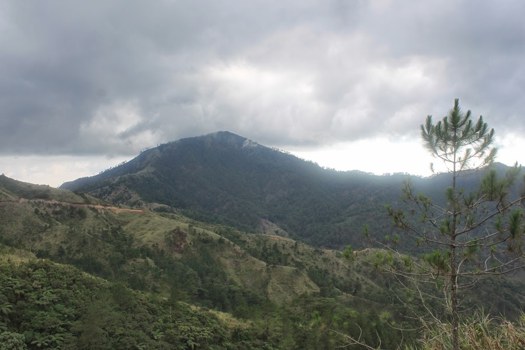
| Mt. Ugo / Mt. Ugu |
Mt. Ugo (also regarded as Mt. Ugu) was personally chosen by the inductees due to the different challenges that the said mountain poses. Besides, being a traditional traverse climb, it is expected that the inductees will be introduced to the culture of the locals in both Nueva Vizcaya and Benguet. Of course, the highly esteemed views of the Cordillera, the cool weather even during the searing heat of summer and the famous "sea of clouds" that is prevalent in the area were some of the added perks that made it easier for the group to decide.
As the pioneer batch of Skookum, there were actually six of us, Allan, Jaime, Bogs, Lennon, Bette and me (Oliver).
 |
| Batch 1 |
Our bus bound for Santiago, Isabela left the Victory Liner Terminal beneath the Kamias flyover (just before you reach East Avenue on the northbound lane) at 11:00PM. Please take note that while the bus that we took went the customary route (through the different towns of Bulacan and southern Nueva Ecija), there are already trips that use the SCTEX, eventually passing through the Tarlac-Sta.Rosa Highway.
An hour and a half into the trip, we had our 1st stopover somewhere in Bulacan. It is a good chance for you to either eat some late dinner, buy additional snacks, or just answer the call of nature.
The bus shall pass through the Maharlika Highway and is expected to reach the Dalton Pass at about 4 hours and a half into the trip. It was a good thing that I was deep asleep when the bus was negotiating the dizzying twists and turns of this fabled gateway to the Cagayan Valley.
After almost 6 hours, we finally arrived at our initial destination, the CCQ Bus Stop & Restaurant in Aritao, Nueva Vizcaya. This is where mountaineers planning to scale the heights of Mt. Ugo usually rendezvous with their respective rented jeepneys that will transport them up to Kayapa, Nueva Vizcaya.
 |
| Waiting for the other mountaineers |
While we were already ready to go, our driver mentioned that since there were only six of us, and that they are expecting the arrival of at least 10 other mountaineers, they asked us if we can at least wait for the other group. Initially, we accommodated their request but after almost an hour of waiting, with the arrival and ensuing departure of at least 3 buses, we decided that we cannot wait for them any longer as our itinerary has already been compromised.
So on we go to the town of Kayapa at exactly 6:20AM. Since we cannot contain the excitement that persistently multiplies within us, all 6 of us decided to try top loading.
With the fast pace that we were travelling, add the open country that we were in, the cool wind that kiss our faces and still sleepy bodies, we cannot really contain our excitement as we all scratched one off our respective bucket lists.
 |
| Open Highway |
 |
| 1st Bridge along the Baguio-Nueva Vizcaya Highway |
 |
| Zigzag |
After almost an hour of traversing 30 kilometers (29 kilometers form the intersection / highway) of twists, turns, ups, downs, and countless magnificent views, we finally arrived at the scenic and quaint town of Kayapa, Nueva Vizcaya.
Our contact, Mang Alex immediately welcomed us. We then proceeded to the market to buy additional provisions and had breakfast at the nearby eatery. Wow, the food is just superb considering that it only costs P60.00 per meal (including unlimited highland rice).
 |
| Kayapa Proper |
 |
| Kayapa Town Hall |
 |
| Kayapa Public Market |
After we were done packing our things and provisions, we then proceeded to register at the police station. We were not required to pay any registration fee as we were only obliged to list our names, contact numbers, and indicate a contact person/number should any uneventful incident happen while we are in the mountains.
 |
| Registration Site |
A guide (Ate Concepcion) and a porter (Kuya Celso) were assigned to us. And after a brief chit chat with the Mang Alex and other locals, we immediately started our ascent up the Cordillera. (Actually, we were already behind by almost 2 hours when compared with our intended itinerary because of our noble act of waiting for the other mountaineers, and of course, our decision to have a hearty breakfast than a light snack).
 |
| Mang Alex...in the black shirt |
It is widely known that the hardest parts
of the trail up Mt. Ugo are in fact located at the start (going to
Indupit Village) and at the final assault (after Domolpos Village) up this
highly regarded peak.
The trail starts with paved stairs in an inclined ascent, so before we
really started to pant and rant, we decided to have here our customary prayer. The stairway then gave way to a concrete footpath as we
continued to snake our way up. We also passed by households and vegetable
gardens.
 |
| Jump-off Point |
 |
| Concrete Stairs |
It was just very surprising that even prior to the
concrete trail turning to dirt path, we have already entered the beautiful pine forest. There is also a water source 40 minutes into the hike. (It really is a
faucet inside a fenced front yard of a house). As we were already in a higher
elevation at this time, the very picturesque view of Kayapa bade us farewell.
 |
| Pine Forest |
 |
| One of the wooden gates / fences |
Here, as participants to the National Mountain
Clean-up Day, we immediately tried to pick up whatever garbage that we see along the trail. There were then only sporadic pieces of thrash, maybe because the groups that went ahead of us have already did their share. Another good reason would be the fact that since the mountain is really not that easy to climb, maybe only hardcore mountaineers have dared to climb Mt. Ugu.
 |
| It's clean-up time..yet the trail was relatively clean |
 |
| One of our many rest stops |
Considering our relaxed pace, we arrived at the 1st
waiting shed after an hour and twenty minutes. We have already hurdled (literally) past occasional gates/fences (reminiscent of the trail in Mt. Ampacao).
And after 2 hours of intense climbing, we were able to reach the 2nd
waiting shed. Kuya Celso was already pointing at us the area in the mountain
where Indupit Village is located.
 |
| Just after the 1st waiting shed |
 |
| And the ascent goes on... |
 |
| Now going deeper into the forest...with Bogs, Lennon and Bette |
 |
| 2nd waiting shed...Indupit is getting nearer |
 |
| Another wooded gate / fence |
After gorging our favorite trail food,
chocolates and nuts, we commenced our assault to Indupit. We arrived at Indupit
at exactly 12:00 high noon, or 3 hours and 30 minutes into our hike. We were
greeted by a cooing hen and a small dog.
 |
| The 1st store...the toilet goes to the left.. |
 |
| The store on the other side of the church/chapel |
Our cooks for lunch were Bogs and Allan, as
ably assisted by Bette and Jaime. They prepared Pork Nilaga which was really
oh so good. One do not always get to eat such scrumptious meals in the
mountains, but I would lay claim that our love for good food is one facet that
is inherent in us Skookum Mountaineers. Mind you, we were already devouring
chicharon while cooking, and we likewise have sliced apples for dessert.
 |
| Native Pork....Nilaga...yummy. |
 |
| Some of the houses have solar panels....Kuya Celso said that it costs at least P2500.00 |
 |
| and there we go... |
 |
| it's just a walk in the park....:) |
 |
| open sesame... |
Along the way, we likewise
encountered the kilometer posts for the King of the Mountain sky running event.
Since this part of the trail is of the open type, the views will surely leave
you breathless. However, you will be exposed to the sun so be ready. We were
just so lucky (or so we claim) because the weather was then cloudy and windy.
 |
| Allan |
 |
| Team Relax |
 |
| Rolling and winding terrain |
 |
| Jump Shot |
 |
| yes...that's the trail on the other side of the mountain |
We arrived at the split going to Ansipsip after an hour. This area is
inside the 10-kilometer post. And 10 minutes later, we reached the other fork after
the 9-kilometer mark where a sign welcoming you to (presumably it leads to) the
Ansipsip Primary School. Here, the weather really started to get awry as the
impending thunderstorms became evident. There were also landslides along the
way which according to Kuya Celso was caused by the incessant rains a day
before.
 |
| Mt. Ugo to the left...Ansipsip to the right |
 |
| The other trail just before the bend leading to the Domolpos/Ansipsip waiting shed |
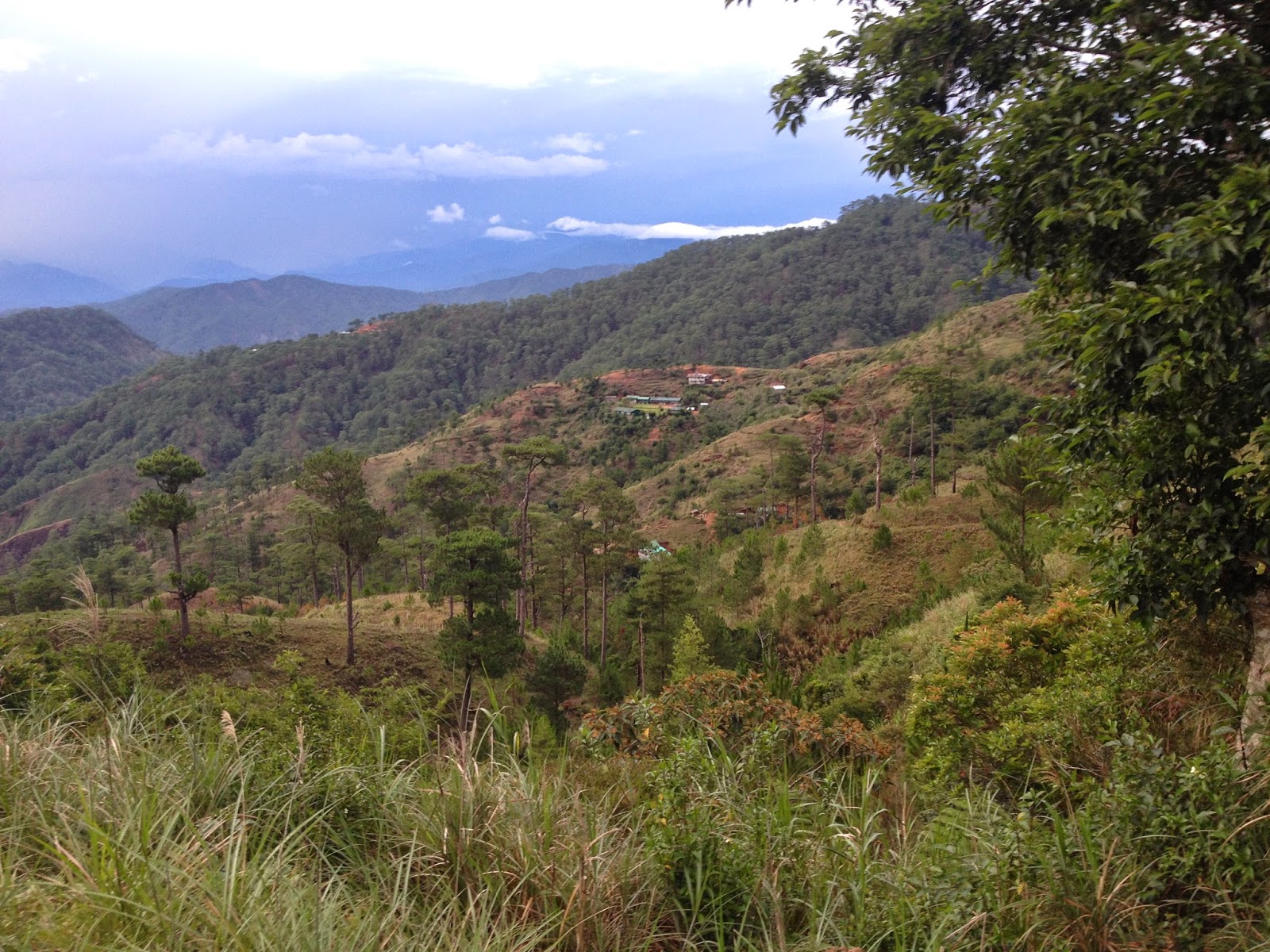
We reached the fabled Domolpos / Ansipsip waiting shed
15 minutes later. Here, we were acknowledged by the grandness of Mt. Ugo
and the splendid views of the other peaks of the Cordillera. So we spent a considerable
time resting and taking pictures here. Domolpos and Ansipsip were likewise visible
from a distance. Kuya Celso also mentioned that we are already within
the boundaries of Tinongdan, Itogon, Benguet. So I guess, the rain then was welcoming
us to the other side of the Cordillera.
 |
| Waiting Shed |
 |
| Allan and Jaime |
 |
| Rain is imminent |
While our initial target really is to get
to the camp site near the summit (even if we do some night trekking), our guide
Ate Concepcion is against the idea since according to her, they still had to
trek back down the mountain and go home to Domolpos. We were surprised by this
revelation really as we all expected that they will similarly camp with us
(same with all our previous guides in different mountains).
 |
| Mt. Ugu...the camp site is a clearing 15 minutes before the summit |
As such, we can never really do anything
but to compromise. We acceded to their proposition that we put up an emergency camp at the waiting shed
located near the 4-kilometer mark, where a house (still under construction) is incidentally located. According to Kuya Celso, we can seek refuge there in case the weather
gets out of hand. After spending 20 minutes at the waiting shed (Domolpos/Ansipsip),
we then pushed on.
We reached the end of the widened portion of the trail
in 6-kilometer post after 20 minutes. From here, one has to go down the rock-strewn foot
path along the side of the mountain. This will continue for more or less 15
minutes until you arrive at the final water source.
From the trail, one needs to climb about 10
meters and pull out the rubber tube from the repository. Just ensure that you
will return the tube to its former alignment since Kuya Celso said that this is
the same water source of the people of Domolpos. Incidentally, the rain poured
while we were getting water, and it was really was so cold. It was a good thing that the
rain stopped as we neared the waiting shed at the 4-kilometer post (Domolpos). A rainbow even
appeared on the horizon.
 |
| The Domolpos waiting shed...Mt. Ugo at the back |
 |
| Domolpos Village....Ansipsip Village is seen on the far left side of the photo |
 |
| Rainbow |
At around 5:30PM, we finally arrived at the
waiting shed. After we have scouted the area, we decided that the clearing
just above the waiting shed would be a better camp site.

Since it seemed that there is no stopping the rain, we decided to finally call it a night at around 8:30PM as most of us were already dripping wet. Besides, we still have to get as much rest as possible since we are scheduled to break camp at 3:30AM for the final assault up Mt. Ugo so that we can be just in time for the "sea of clouds".
 |
| cooking time |
 |
| diskarte ni Bogs |
 |
| "Red Team" |
 |
| Pasta, porkchops and squid :) |
***Traipsing Chronicles 001
Mt. Ugo / Mt. Ugu
Kayapa, Nueva Vizcaya Traverse to Itogon, Benguet
2150 MASL
Major Climb: 6/9
Jump-off Point: Kayapa Proper, Kayapa, Nueva Vizcaya
Exit Point: Tinongdan, Itogon, Benguet
Highlights: Cold Weather; Pine Forest; Mossy Forest; Sea of Clouds
Actual Itinerary - Day 1
2300 - ETD Victory Liner Kamias Terminal (still considered as part of Day 0)
0500 - ETA CCQ Bus Stop (Aritao Nueva Vizcaya)
0620 - Departure from CCQ Bus Stop to Kayapa, Nueva Vizcaya (via rented jeepney)
0720 - Arrival Kayapa Proper
0820 - End - Breakfast at the eatery / Buy Additional Provisions / Repack things / Registration
0830 - Departure Jump off Point
0920 - Arrival at the 1st water source
0940 - Arrival at the 1st waiting shed
1030 - Arrival at the 2nd waiting shed
1100 - Departure 2nd waiting shed to Indupit Village
1200 - Arrival Indupit Village
Lunch / Rest
1445 - Departure Indupit Village
1545 - Arrival junction / fork to Ansipsip Village
1555 - Arrival split / fork / welcome marker to Ansipsip Primary School
1610 - Arrival Ansipsip / Domolpos waiting shed
1630 - Departure Ansipsip / Domolpos waiting shed
1650 - Arrival end of the dirt road / down towards
1705 - Arrival at the last water source (fill-in water bottles / containers)
1730 - Arrival at the 4th kilometer mark (waiting shed / road leading to Domolpos)
1930 - Dinner
2030 - Lights out
Indupit Village. Indupit Village really offers a very rustic
scene where there are about 6 houses with a church/chapel at the center. There are two stores in the area, one beneath the church and the other near the light post at the entrance of the village (you will pass by the store in case you are going to the public toilet). The
locals, especially the children are always ready to greet you with a warm
smile. According to Kuya Celso, it is possible to reach Indupit by means of a motorcycle (habal-habal) or even a jeepney. The peak of Mt. Ugo is
visible in Indupit, on the other side is another panoramic view of Kayapa. A public toilet and a water source are available in Indupit.
Ansipsip Village. Ansipsip Village is part of Kayapa, Nueva Vizcaya. Though we did not pass through the actual village, Kuya Celso said that there is a another trail in the said village that lead to the summit of Mt. Ugo.
Domolpos Village. A part of Tinongdan, Itogon, Benguet. Most of the guides and porters in Mt. Ugo come from this village. It is the village nearest to Mt. Ugo. There is a school in the village where mountaineers are allowed to camp.
Tinongdan, Itogon, Benguet. Tinongdan incidentally is the barangay
having jurisdiction of Mt. Ugo, Domolpos Village, and even Binga Dam.
Water Source. There are at least 3 water sources along the trail. The first is the one located inside a fenced front yard. The second is in Indupit Village. The final water source is located just before the 4-kilometer post. It is a good 2-hour trek to and from the camp site.


Concise! Blog more of our other climbs.
ReplyDelete